File:Electrificación metro madrid.svg
Jump to navigation
Jump to search

Size of this PNG preview of this SVG file: 545 × 599 pixels. Other resolutions: 218 × 240 pixels | 436 × 480 pixels | 698 × 768 pixels | 931 × 1,024 pixels | 1,862 × 2,048 pixels | 1,123 × 1,235 pixels.
Original file (SVG file, nominally 1,123 × 1,235 pixels, file size: 2.31 MB)
Captions
Captions
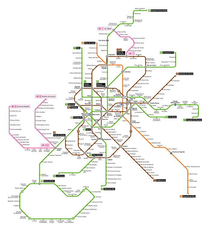
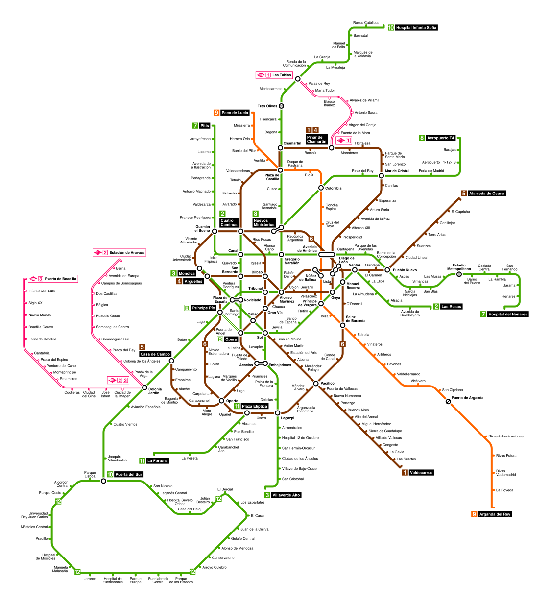
This simplification of the Madrid metro is easier for commuters to read than a literal map
Summary
[edit]| Description |
English: Map of the electrification of the Madrid Metro.
600 V DC (prepared for 1500 V DC) 600 V DC 750 V DC 1500 V DC Español: Mapa de la electrificación del Metro de Madrid
600 Vcc (preparada para 1500 Vcc) 600 Vcc 750 Vcc 1500 Vcc |
| Date | |
| Source | Derived from the file File:Madrid Metro Map.svg, uploaded to Commons |
| Author | Commons user User:Javitomad |

Licensing
[edit]
This file is licensed under the Creative Commons Attribution-Share Alike 4.0 International license.
- You are free:
- to share – to copy, distribute and transmit the work
- to remix – to adapt the work
- Under the following conditions:
- attribution – You must give appropriate credit, provide a link to the license, and indicate if changes were made. You may do so in any reasonable manner, but not in any way that suggests the licensor endorses you or your use.
- share alike – If you remix, transform, or build upon the material, you must distribute your contributions under the same or compatible license as the original.
File history
Click on a date/time to view the file as it appeared at that time.
| Date/Time | Thumbnail | Dimensions | User | Comment | |
|---|---|---|---|---|---|
| current | 18:29, 2 August 2022 | | 1,123 × 1,235 (2.31 MB) | Snooze123 (talk | contribs) | new design |
| 13:36, 9 November 2021 |  | 981 × 1,190 (1.28 MB) | Gust4v048668 (talk | contribs) | Reverted to version as of 21:35, 18 November 2018 (UTC) | |
| 13:34, 9 November 2021 |  | 981 × 1,190 (505 KB) | Gust4v048668 (talk | contribs) | Reverted to version as of 15:57, 23 February 2020 (UTC) | |
| 15:59, 23 February 2020 |  | 981 × 1,190 (853 KB) | Snooze123 (talk | contribs) | Reverted to version as of 11:59, 1 February 2019 (UTC) | |
| 15:57, 23 February 2020 |  | 981 × 1,190 (505 KB) | Snooze123 (talk | contribs) | Indicadas en naranja las líneas que operan a 600Vcc pero pueden hacerlo a 900Vcc | |
| 11:59, 1 February 2019 |  | 981 × 1,190 (853 KB) | Snooze123 (talk | contribs) | Reduced file size | |
| 21:35, 18 November 2018 |  | 981 × 1,190 (1.28 MB) | Snooze123 (talk | contribs) | User created page with UploadWizard |
You cannot overwrite this file.
File usage on Commons
The following 15 pages use this file:
- User:Chumwa/OgreBot/Potential transport maps/2018 November 11-20
- User:Chumwa/OgreBot/Potential transport maps/2019 February 1-9
- User:Chumwa/OgreBot/Public transport information/2018 November 11-20
- User:Chumwa/OgreBot/Public transport information/2019 February 1-9
- User:Chumwa/OgreBot/Public transport information/2020 February 20-29
- User:Chumwa/OgreBot/Public transport information/2021 November 1-10
- User:Chumwa/OgreBot/Public transport information/2022 August 1-10
- User:Chumwa/OgreBot/Transport Maps/2018 November 11-20
- User:Chumwa/OgreBot/Transport Maps/2019 February 1-9
- User:Chumwa/OgreBot/Transport Maps/2020 February 20-29
- User:Chumwa/OgreBot/Transport Maps/2021 November 1-10
- User:Chumwa/OgreBot/Transport Maps/2022 August 1-10
- User:Chumwa/OgreBot/Travel and communication maps/2018 November 11-20
- User:Chumwa/OgreBot/Travel and communication maps/2019 February 1-9
- User:Snooze123/Galería
File usage on other wikis
The following other wikis use this file:
- Usage on cs.wikipedia.org
- Usage on en.wikipedia.org
- Usage on es.wikipedia.org
- Usage on sk.wikipedia.org