File:EldoradoNatlForestMap.png
Jump to navigation
Jump to search
No higher resolution available.
EldoradoNatlForestMap.png (200 × 155 pixels, file size: 47 KB, MIME type: image/png)
Captions
Captions
Add a one-line explanation of what this file represents
| Description |
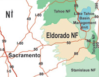
English: Map of the Eldorado National Forest in the central Sierra Nevada, eastern California. 72.9% of the forest is located within El Dorado County, California. The forest is also spelled "El Dorado National Forest". |
| Date | 15 September 2005 (original upload date) |
| Source | Archived source link |
| Author |
Original map: U.S. Forest Service |
Licensing
[edit]
This image is a work of the Forest Service of the United States Department of Agriculture. As a work of the U.S. federal government, the image is in the public domain.
|
Original upload log
[edit]
The original description page was here. All following user names refer to en.wikipedia.
- 2005-09-15 18:10 Howcheng 200×155× (48048 bytes) Map of [[Eldorado National Forest]], cropped from http://www.fs.fed.us/r5/eldorado/local-resources/images/0503-Eldorado-LocMap02.jpg
File history
Click on a date/time to view the file as it appeared at that time.
| Date/Time | Thumbnail | Dimensions | User | Comment | |
|---|---|---|---|---|---|
| current | 00:29, 3 June 2009 | | 200 × 155 (47 KB) | File Upload Bot (Magnus Manske) (talk | contribs) | {{BotMoveToCommons|en.wikipedia|year={{subst:CURRENTYEAR}}|month={{subst:CURRENTMONTHNAME}}|day={{subst:CURRENTDAY}}}} {{Information |Description={{en|Map of en:Eldorado National Forest, cropped from http://www.fs.fed.us/r5/eldorado/local-resources |
You cannot overwrite this file.
File usage on Commons
There are no pages that use this file.
File usage on other wikis
The following other wikis use this file:
- Usage on en.wikipedia.org