File:El Vizcaíno Biosphere Reserve Landsat picture big.jpg

Original file (4,800 × 4,800 pixels, file size: 3.83 MB, MIME type: image/jpeg)
Captions
Captions
Summary
[edit]
| Description |
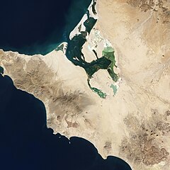
English: Midway down the Baja California Peninsula lies a wildlife reserve that the United Nations Educational, Scientific, and Cultural Organization (UNESCO) has declared a World Heritage site. Encompassing two lagoons and a large stretch of land between them, El Vizcaíno Biosphere Reserve provides a winter home for gray whales and other marine mammals, and habitat for thousands of migratory waterfowl. Plant life in the reserve includes Sonoran Desert vegetation and, at the water’s edge, mangroves.
On December 5, 2002, the Enhanced Thematic Mapper Plus on the Landsat 7 satellite captured this image of the western part of the reserve, including Lago Ojo de Liebre. In the western reaches of El Vizcaíno, elevations are low and land conditions are dry. Annual precipitation is generally less than 80 millimeters (3 inches) per year, and water evaporates so quickly here that rivers rarely reach the ocean. Meanwhile, constant winds organize loose sands into dunes. But the land is not completely barren: More than 400 plant species have been identified in the reserve, many of them shrubs or herbaceous plants. The rocks in this region are mostly sedimentary—made from material that was eroded by wind or water, and later deposited in new places. Volcanic rocks protrude through the sedimentary layers and can be distinguished by their darker colors and rugged surfaces. An assemblage of volcanic rocks appears southeast of Lago Ojo de Liebre This image also shows evidence of human activity. So some of the clearest green areas in this image result not from lush vegetation but from salt extraction. Along the edges of Lago Ojo de Liebre and near the town of Guerrero Negro, a massive salt mine produces roughly 7 million tons of salt each year. The salt works contrast with their surroundings thanks to their rectangular outlines and green hues.Deutsch: Etwa in der Mitte der Halbinsel Niederkalifornien liegt ein Naturreservat, das die United Nations Educational, Scientific, and Cultural Organization (UNESCO) zu einer Welterbestätte erklärt hat. Es umfaßt zwei Lagunen und einen großen Landstreifen dazwischen. Das El-Vizcaíno-Biosphärenreservat ist eine Überwinterungsstätte für Grauwale und andere Meeressäugetiere und Habitat für tausende von Wasserzugvögeln. Zur Vegetation in dem Reservat gehören die für die Sonora typische Wüstenvegetation und, am Uferstreifen, Mangroven.
Am 5. Dezember 2002 hat der Enhanced Thematic Mapper Plus an Bord des Satelliten Landsat 7 dieses Bild vom westlichen Teil des Reservats aufgenommen, einschließlich des Lago Ojo de Liebre. In den westlichen Ausläufern von El Vizcaíno liegt das Gelände nur wenig über dem Meeresspiegel, und das Land ist trocken. Die jährliche Niederschlagsmenge liegt im allgemeinen unter 80 Millimetern, und Wasser verdunstet hier so rasch, dass die Fließgewässer kaum die Küste erreichen. Gleichzeitig häufen andauernde Winde losen Sand zu Dünen auf. Doch ist das Land nicht vollständig der Dürre ausgesetzt; mehr als 400 Pflanzenspezies wurden in dem Biosphärenreservat gezählt, viele von ihnen Gestrüpp oder Krautpflanzen. Das Gestein in dieser Region entstand weitgehend durch Sedimentierung von Material, das durh Wind oder Wasser erodiert worden war und an anderer Stelle abgelagert wurde. Vulkanisches Gestein ist zwischen den Sedimentschichten verschiedentlich anstehend und kann durch seine dunklere Farbe und die stäarker zerklüftete Oberfläche. Eine Ansammlung vulkanischen Gesteins ist auf dem Bild südöstlich des Lago Ojo de Liebre sichtbar. Dieses Bild zeigt auch Spuren menschlicher Aktivität. So stammen einige der am deutlichsten grünen Gebiete nicht von üppiger Vegetation sondern von der Salzgewinnung. Entlang der Ufer des Lago Ojo de Liebre und in der Nähe der Stadt Guerrero Negro erzeugt ein Salzwerk jährlich etwa sieben Millionen Tonnen Salz. Die Salzgärten kontrastieren durch ihre regelmäßigen rechteckigen Formen und grüne Färbung mit der Umgebung. |
| Date | NASA Earth Observatory image by Jesse Allen and Robert Simmon, us2002-12-03 |
| Source | http://earthobservatory.nasa.gov/IOTD/view.php?id=77499 |
| Author | ing Landsat data from the United States Geological Survey. Caption by Michon Scott. |
| Other versions | File:El Vizcaíno Biosphere Reserve Landsat picture annotated.jpg |
Licensing
[edit]
| This file is in the public domain in the United States because it was solely created by NASA. NASA copyright policy states that "NASA material is not protected by copyright unless noted". (See Template:PD-USGov, NASA copyright policy page or JPL Image Use Policy.) | ||
 |
Warnings:
|
File history
Click on a date/time to view the file as it appeared at that time.
| Date/Time | Thumbnail | Dimensions | User | Comment | |
|---|---|---|---|---|---|
| current | 20:32, 25 March 2012 | | 4,800 × 4,800 (3.83 MB) | Matthiasb (talk | contribs) | {{Information |Description ={{en|1=Midway down the Baja California Peninsula lies a wildlife reserve that the United Nations Educational, Scientific, and Cultural Organization (UNESCO) has declared a World Heritage site. Encompassing two lagoons and... |
You cannot overwrite this file.
File usage on Commons
There are no pages that use this file.
File usage on other wikis
The following other wikis use this file:
- Usage on en.wikivoyage.org
- Usage on es.wikipedia.org
- Usage on hu.wikipedia.org
- Usage on pt.wikipedia.org