File:Eingangsbereich Ingenieurschule für Glastechnik.jpg
Original file (4,919 × 3,271 pixels, file size: 9.8 MB, MIME type: image/jpeg)
Captions
Summary
[edit]DescriptionEingangsbereich Ingenieurschule für Glastechnik.jpg |
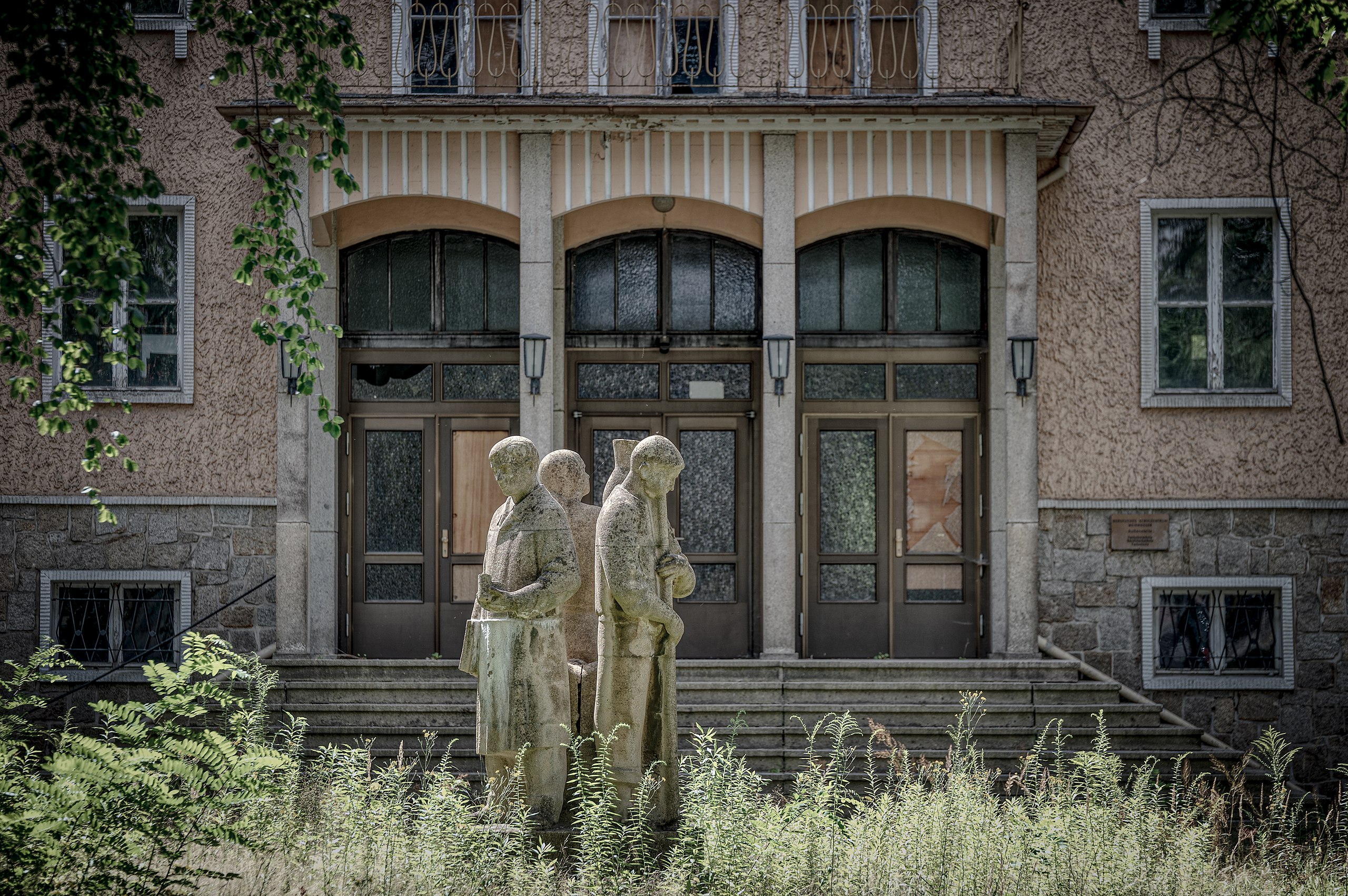
Deutsch: 1953 wurde an der Berliner Straße in Weißwasser die Glasfachschule gebaut, 1955 wurde die Betonplastik „Kollegen bei der Glasschmelze“ vor dem Hauptportal hinzugefügt. Seit 2009 die Nutzung als Berufliches Schulzentrum eingestellt wurde, steht das Gebäude leer.
|
||
Date | |||
Source | Own work | ||
Author | GZagatta |
Camera location | 51° 30′ 11.65″ N, 14° 38′ 22.17″ E | View this and other nearby images on: OpenStreetMap | 51.503237; 14.639493 |
---|
Licensing
[edit]- You are free:
- to share – to copy, distribute and transmit the work
- to remix – to adapt the work
- Under the following conditions:
- attribution – You must give appropriate credit, provide a link to the license, and indicate if changes were made. You may do so in any reasonable manner, but not in any way that suggests the licensor endorses you or your use.
- share alike – If you remix, transform, or build upon the material, you must distribute your contributions under the same or compatible license as the original.
This image was uploaded as part of Wiki Loves Monuments 2021.
Afrikaans ∙ Alemannisch ∙ العربية ∙ جازايرية ∙ azərbaycanca ∙ Bikol Central ∙ беларуская ∙ беларуская (тарашкевіца) ∙ български ∙ বাংলা ∙ brezhoneg ∙ bosanski ∙ català ∙ čeština ∙ Cymraeg ∙ dansk ∙ Deutsch ∙ Zazaki ∙ Ελληνικά ∙ English ∙ Esperanto ∙ español ∙ eesti ∙ euskara ∙ فارسی ∙ suomi ∙ français ∙ Frysk ∙ Gaeilge ∙ galego ∙ עברית ∙ हिन्दी ∙ hrvatski ∙ magyar ∙ հայերեն ∙ Bahasa Indonesia ∙ Ido ∙ italiano ∙ 日本語 ∙ ქართული ∙ 한국어 ∙ кыргызча ∙ Lëtzebuergesch ∙ latviešu ∙ Malagasy ∙ македонски ∙ മലയാളം ∙ Bahasa Melayu ∙ Malti ∙ norsk bokmål ∙ नेपाली ∙ Nederlands ∙ norsk nynorsk ∙ norsk ∙ polski ∙ português ∙ português do Brasil ∙ română ∙ русский ∙ sicilianu ∙ davvisámegiella ∙ slovenčina ∙ slovenščina ∙ shqip ∙ српски / srpski ∙ svenska ∙ ไทย ∙ Tagalog ∙ Türkçe ∙ українська ∙ اردو ∙ oʻzbekcha / ўзбекча ∙ Yorùbá ∙ 中文 ∙ 中文(中国大陆) ∙ 中文(简体) ∙ 中文(繁體) ∙ 中文(香港) ∙ 中文(臺灣) ∙ +/− |
File history
Click on a date/time to view the file as it appeared at that time.
Date/Time | Thumbnail | Dimensions | User | Comment | |
---|---|---|---|---|---|
current | 18:17, 21 September 2021 | 4,919 × 3,271 (9.8 MB) | GZagatta (talk | contribs) | Uploaded own work with UploadWizard |
You cannot overwrite this file.
File usage on Commons
The following page uses this file:
Metadata
This file contains additional information such as Exif metadata which may have been added by the digital camera, scanner, or software program used to create or digitize it. If the file has been modified from its original state, some details such as the timestamp may not fully reflect those of the original file. The timestamp is only as accurate as the clock in the camera, and it may be completely wrong.
Camera manufacturer | NIKON CORPORATION |
---|---|
Camera model | NIKON D4S |
Author | Zagatta |
Copyright holder |
|
Exposure time | 1/350 sec (0.0028571428571429) |
F-number | f/4 |
ISO speed rating | 200 |
Date and time of data generation | 14:02, 6 August 2021 |
Lens focal length | 140 mm |
User comments | Photo by Zagatta |
Latitude | 51° 30′ 11.65″ N |
Longitude | 14° 38′ 22.18″ E |
Altitude | 139 meters above sea level |
City shown | Weißwasser |
Horizontal resolution | 240 dpi |
Vertical resolution | 240 dpi |
Software used | Adobe Photoshop Lightroom Classic 10.3 (Windows) |
File change date and time | 10:46, 10 August 2021 |
Exposure Program | Aperture priority |
Exif version | 2.31 |
Date and time of digitizing | 14:02, 6 August 2021 |
APEX shutter speed | 8.451211 |
APEX aperture | 4 |
APEX exposure bias | 0 |
Maximum land aperture | 2.9708536585366 APEX (f/2.8) |
Metering mode | Pattern |
Light source | Unknown |
Flash | Flash did not fire |
DateTimeOriginal subseconds | 36 |
DateTimeDigitized subseconds | 36 |
Color space | sRGB |
Focal plane X resolution | 1,368.8888888889 |
Focal plane Y resolution | 1,368.8888888889 |
Focal plane resolution unit | 3 |
Sensing method | One-chip color area sensor |
File source | Digital still camera |
Scene type | A directly photographed image |
Custom image processing | Normal process |
Exposure mode | Auto exposure |
White balance | Auto white balance |
Digital zoom ratio | 1 |
Focal length in 35 mm film | 140 mm |
Scene capture type | Standard |
Scene control | None |
Contrast | Normal |
Saturation | Normal |
Sharpness | Normal |
Subject distance range | Unknown |
GPS time (atomic clock) | 12:02 |
Satellites used for measurement | 10 |
Reference for direction of image | Magnetic direction |
Direction of image | 192.59 |
Geodetic survey data used | WGS 84 |
GPS date | 6 August 2021 |
GPS tag version | 0.0.3.2 |
Serial number of camera | 2020263 |
Lens used | TAMRON SP 70-200mm F2.8 Di VC USD A009N |
Rating (out of 5) | 1 |
Date metadata was last modified | 12:46, 10 August 2021 |
Unique ID of original document | 7BB7A2E4D6D928C8B328D5958F84157B |
Province or state shown | Sachsen |
Country shown | Deutschland |
Sublocation of city shown | Weißwasser |
Code for country shown | DE |
IIM version | 4 |
Structured data
some value
51°30'11.653"N, 14°38'22.175"E
0.00285714285714285714 second
140 millimetre
200
6 August 2021
image/jpeg
- Cultural heritage monuments in Saxony with known ID
- Cultural heritage monuments in Saxony missing SDC location of creation
- Files with coordinates missing SDC location of creation
- CC-BY-SA-4.0
- Self-published work
- Images from Wiki Loves Monuments 2021
- Images from Wiki Loves Monuments 2021 in Germany
- Images from Wiki Loves Monuments missing SDC location of creation
- Images from Wiki Loves Monuments 2021, DE-SN
- Uploaded via Campaign:wlm-de-sn