File:Egypt-4B-042 - Temple of Hatshepsut (2217384260).jpg

Original file (2,560 × 1,920 pixels, file size: 4.28 MB, MIME type: image/jpeg)
Captions
Captions
Summary
[edit].jpg&action=edit§ion=1)
| Description |
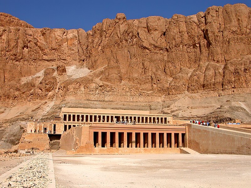
The Temple of Hatshepsut arose as a necropolis, consecrated to the goddess Hathor in the eleventh dynasty (2120 - 1991 BC). It was then abandoned until queen Hatshepsut took it over some five hundred years later. After the abandonment (again), it was for a period turned into a monastery, whose existence there is the reason for its being so well preserved, has given it its present Arabic name, Deir el-Bahri. The temple is built into the rock itself, and consists of three terraces. It was created by the famous architect Senmut. Queen Hatshepsut is best known as the only woman who actually reigned as a pharaoh - probably to her son's annoyance. Hatshepsut took over the rule of Egypt when her husband, Thutmosis II, died. Thutmosis II was incidentally both her husband and half-brother. When her son, Thutmosis III, came of age, she was so unhappy about handing over the power to him that she, together with the priests, figured out a way to avoid it. This way included wearing male clothes, as well as the false beard made of wood and leather worn by all pharaohs. On November 17, 1997, Islamist militants massacred 60 foreign tourists and four Egyptians on the West Bank outside the Temple of Hatshepsut; police killed the six assailants. The attack is believed to have been financed by Saudi terrorist Osama bin Laden. Deir el-Bahri, Egypt |
| Date | |
| Source | Egypt-4B-042 - Temple of Hatshepsut |
| Author | Dennis Jarvis from Halifax, Canada |
| Permission (Reusing this file) |
Quote from photographer on numerous files
|
| Camera location | | View this and other nearby images on: OpenStreetMap |
|---|
.jpg¶ms=025.683612_N_0032.640380_E_globe:Earth_type:camera_source:Flickr_&language=en)
Licensing
[edit].jpg&action=edit§ion=2)
- You are free:
- to share – to copy, distribute and transmit the work
- to remix – to adapt the work
- Under the following conditions:
- attribution – You must give appropriate credit, provide a link to the license, and indicate if changes were made. You may do so in any reasonable manner, but not in any way that suggests the licensor endorses you or your use.
- share alike – If you remix, transform, or build upon the material, you must distribute your contributions under the same or compatible license as the original.
| This image was originally posted to Flickr by archer10 (Dennis) 116M Views at https://flickr.com/photos/22490717@N02/2217384260 (archive). It was reviewed on 1 March 2018 by FlickreviewR 2 and was confirmed to be licensed under the terms of the cc-by-sa-2.0. |
File history
Click on a date/time to view the file as it appeared at that time.
| Date/Time | Thumbnail | Dimensions | User | Comment | |
|---|---|---|---|---|---|
| current | 15:14, 1 March 2018 | | 2,560 × 1,920 (4.28 MB) | Artix Kreiger 2 (talk | contribs) | Transferred from Flickr via Flickr2Commons |
You cannot overwrite this file.
File usage on Commons
There are no pages that use this file.
.jpg&oldid=890835672)