File:Edwards Air Force Base, California – satellite image.jpg
Jump to navigation
Jump to search

Size of this preview: 747 × 599 pixels. Other resolutions: 299 × 240 pixels | 598 × 480 pixels | 971 × 779 pixels.
Original file (971 × 779 pixels, file size: 313 KB, MIME type: image/jpeg)
Captions
Captions
Edwards Air Force Base
Summary
[edit]| Description |
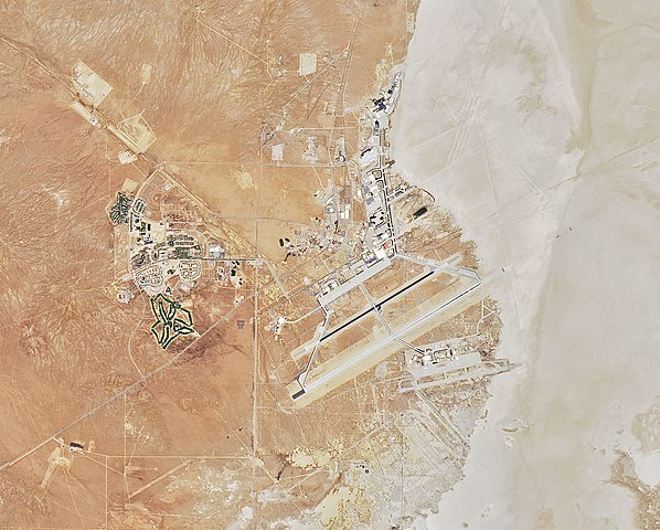
English: Satellite image of the Edwards Air Force Base in California. Located at the Rogers Dry Lake in the Mojave Desert in California.
On July 1, 2019, Operational Land Imager (OLI) on NASA's Landsat 8 acquired this image. |
| Date | |
| Source | https://earthobservatory.nasa.gov/images/145607/cameron-ridge?src=ve |
| Author | NASA |
_%E2%80%93_satellite_image.jpg)
Licensing
[edit]
| This file is in the public domain in the United States because it was solely created by NASA. NASA copyright policy states that "NASA material is not protected by copyright unless noted". (See Template:PD-USGov, NASA copyright policy page or JPL Image Use Policy.) | ||
 |
Warnings:
|
File history
Click on a date/time to view the file as it appeared at that time.
| Date/Time | Thumbnail | Dimensions | User | Comment | |
|---|---|---|---|---|---|
| current | 21:49, 12 October 2019 | | 971 × 779 (313 KB) | A11w1ss3nd (talk | contribs) | File:Mojave Desert, Tehachapi Mountains, and San Joaquin Valley (California) – satellite image.jpg cropped 89 % horizontally, 85 % vertically using CropTool with precise mode. |
You cannot overwrite this file.
File usage on Commons
The following 2 pages use this file:
File usage on other wikis
The following other wikis use this file:
- Usage on de.wikipedia.org
- Usage on ja.wikipedia.org