File:Edward Street - geograph.org.uk - 231403.jpg
Jump to navigation
Jump to search
No higher resolution available.
Edward_Street_-_geograph.org.uk_-_231403.jpg (640 × 491 pixels, file size: 124 KB, MIME type: image/jpeg)
Captions
Captions
Add a one-line explanation of what this file represents
Summary
[edit]
| Description |
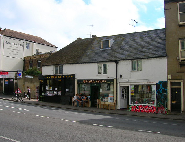
English: Edward Street. Head south down Grand Parade then Pavilion Parade until the junction with Edward Street is reached. Edward Street was built on what was known as a leakway a path dividing two separate Laines, in this case Hilly Laine to the north and Little Laine to the south. This area was built up from 1800 onwards and the Hilly Laine area soon became home to the town's slums. Edward Street was once only 25 feet across but the northern side was cleared and widened between 1961-64 as a planned dual carriageway out of town. The street retains a number of buildings on its southern side as a reminder of the street's previous role as a shopping area for the poorer areas of town. What shops remain now serve the big employers of the northern side of the street.
Click on the link to take you to the next page. https://www.geograph.org.uk/photo/231411 |
| Date | |
| Source | From geograph.org.uk |
| Author | Simon Carey |
| Attribution (required by the license) | Simon Carey / Edward Street / |
| Camera location | | View this and other nearby images on: OpenStreetMap |
|---|
_heading:135.00&language=en)
| Object location | | View this and other nearby images on: OpenStreetMap |
|---|
_heading:135.00&language=en)
Licensing
[edit]

|
This image was taken from the Geograph project collection. See this photograph's page on the Geograph website for the photographer's contact details. The copyright on this image is owned by Simon Carey and is licensed for reuse under the Creative Commons Attribution-ShareAlike 2.0 license.
|
This file is licensed under the Creative Commons Attribution-Share Alike 2.0 Generic license.
Attribution: Simon Carey
- You are free:
- to share – to copy, distribute and transmit the work
- to remix – to adapt the work
- Under the following conditions:
- attribution – You must give appropriate credit, provide a link to the license, and indicate if changes were made. You may do so in any reasonable manner, but not in any way that suggests the licensor endorses you or your use.
- share alike – If you remix, transform, or build upon the material, you must distribute your contributions under the same or compatible license as the original.
File history
Click on a date/time to view the file as it appeared at that time.
| Date/Time | Thumbnail | Dimensions | User | Comment | |
|---|---|---|---|---|---|
| current | 23:48, 31 January 2010 | | 640 × 491 (124 KB) | GeographBot (talk | contribs) | == {{int:filedesc}} == {{Information |description={{en|1=Edward Street. Head south down Grand Parade then Pavilion Parade until the junction with Edward Street is reached. Edward Street was built on what was known as a leakway a path dividing two separate |
You cannot overwrite this file.
File usage on Commons
There are no pages that use this file.