File:Edilson 2014 track.png
Jump to navigation
Jump to search

Size of this preview: 708 × 599 pixels. Other resolutions: 284 × 240 pixels | 567 × 480 pixels | 907 × 768 pixels | 1,210 × 1,024 pixels | 2,419 × 2,048 pixels | 2,700 × 2,286 pixels.
Original file (2,700 × 2,286 pixels, file size: 1,005 KB, MIME type: image/png)
Captions
Captions
Add a one-line explanation of what this file represents
Summary
| Description |
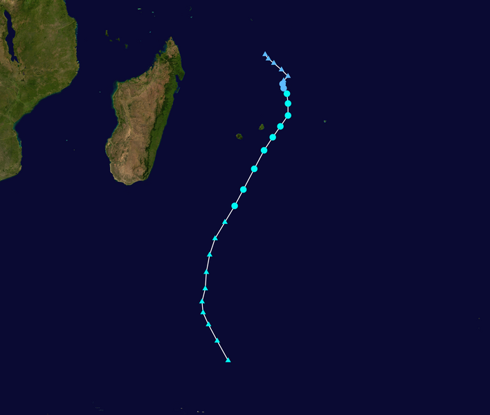
English: Track map of Severe Tropical Storm Edilson of the 2013-14 South-West Indian Ocean cyclone season. The points show the location of the storm at 6-hour intervals. The colour represents the storm's maximum sustained wind speeds as classified in the (see below), and the shape of the data points represent the nature of the storm, according to the legend below. Tropical depression (≤38 mph, ≤62 km/h)
Tropical storm (39–73 mph, 63–118 km/h)
Category 1 (74–95 mph, 119–153 km/h)
Category 2 (96–110 mph, 154–177 km/h)
Category 3 (111–129 mph, 178–208 km/h)
Category 4 (130–156 mph, 209–251 km/h)
Category 5 (≥157 mph, ≥252 km/h)
Unknown
Storm type |
||
| Date | 2014-02-03–2014-02-09 | ||
| Source | Created by Supportstorm using Wikipedia:WikiProject Tropical cyclones/Tracks. The background image is from NASA. Tracking data is from the Joint Typhoon Warning Center[1]. | ||
| Author | Supportstorm | ||
| Source code | Track map data table, if present below, is in HURDAT2 or ATCF format. See format details in [2] and [3], respectively.
|
Licensing
[edit]| This work has been released into the public domain by its author, Supportstorm. This applies worldwide. In some countries this may not be legally possible; if so: Supportstorm grants anyone the right to use this work for any purpose, without any conditions, unless such conditions are required by law. |
File history
Click on a date/time to view the file as it appeared at that time.
| Date/Time | Thumbnail | Dimensions | User | Comment | |
|---|---|---|---|---|---|
| current | 21:35, 25 March 2020 | | 2,700 × 2,286 (1,005 KB) | Supportstorm (talk | contribs) | JTWC/Reunion data |
| 18:23, 1 November 2015 |  | 2,700 × 2,286 (1,004 KB) | Supportstorm (talk | contribs) | IBTrACS | |
| 08:14, 9 February 2014 |  | 1,024 × 746 (194 KB) | Keith Edkins (talk | contribs) | Final operational update | |
| 08:42, 8 February 2014 |  | 1,024 × 644 (181 KB) | Keith Edkins (talk | contribs) | Updated | |
| 08:12, 7 February 2014 |  | 1,024 × 633 (166 KB) | Keith Edkins (talk | contribs) | Updated | |
| 08:13, 6 February 2014 |  | 1,024 × 633 (164 KB) | Keith Edkins (talk | contribs) | Updated | |
| 08:19, 5 February 2014 |  | 1,024 × 633 (176 KB) | Keith Edkins (talk | contribs) | Updated | |
| 08:32, 4 February 2014 |  | 1,024 × 633 (197 KB) | Keith Edkins (talk | contribs) | {{current}}{{Information |Description={{en|Track map of Tropical Disturbance 10 of the [[w:2013–14 South-West Indian Ocean cyclone season|2013–14 South-West Indian Ocean... |
You cannot overwrite this file.
File usage on Commons
The following page uses this file:
- File:10R 2014 track.png (file redirect)
File usage on other wikis
The following other wikis use this file:
- Usage on de.wikipedia.org
- Usage on en.wikipedia.org
- Usage on ko.wikipedia.org
- Usage on vi.wikipedia.org
- Usage on zh.wikipedia.org