File:EdaMap8.jpg
Jump to navigation
Jump to search

Size of this preview: 577 × 599 pixels. Other resolutions: 231 × 240 pixels | 462 × 480 pixels | 740 × 768 pixels | 986 × 1,024 pixels | 1,973 × 2,048 pixels | 6,246 × 6,485 pixels.
Original file (6,246 × 6,485 pixels, file size: 1.86 MB, MIME type: image/jpeg)
Captions
Captions
Add a one-line explanation of what this file represents
Summary
[edit]
| Description |
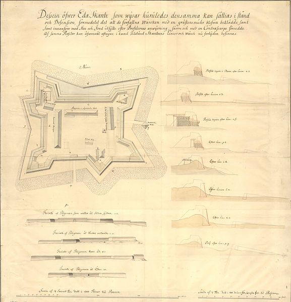
English: Map showing the earthworks at Eda sconce, Värmland in Sweden 1772, and suggestions of improvement with stonewalls and higher eartworks.
Svenska: Förslagsritning över Eda skans år 1772, som visar det befintliga tillståndet för vallarna, och förslag på förbättringar med sten och högre jordvallar. |
| Date | |
| Source | Krigsarkivet: Sverige, stads- och fästningsplaner, Eda skans, 0424:024:014a |
| Author | Unknown author |
Licensing
[edit]
|
This work is in the public domain in its country of origin and other countries and areas where the copyright term is the author's life plus 100 years or fewer. | |
| This file has been identified as being free of known restrictions under copyright law, including all related and neighboring rights. | |
File history
Click on a date/time to view the file as it appeared at that time.
| Date/Time | Thumbnail | Dimensions | User | Comment | |
|---|---|---|---|---|---|
| current | 18:50, 27 May 2014 | | 6,246 × 6,485 (1.86 MB) | Dagjoh (talk | contribs) | {{Information |Description ={{en|1=Map showing the earthworks at Eda sconce, Värmland in Sweden 1772, and suggestions of improvement with stonewalls and higher eartworks. }} {{sv|1=Förslagsritning över Eda skans år 1772, som visar det befintliga... |
You cannot overwrite this file.
File usage on Commons
There are no pages that use this file.