File:Eccles Road Station - opening of the crossing gates - geograph.org.uk - 1398996.jpg
Jump to navigation
Jump to search

Size of this preview: 548 × 600 pixels. Other resolutions: 219 × 240 pixels | 585 × 640 pixels.
Original file (585 × 640 pixels, file size: 97 KB, MIME type: image/jpeg)
Captions
Captions
Add a one-line explanation of what this file represents
Summary
[edit]
| Description |
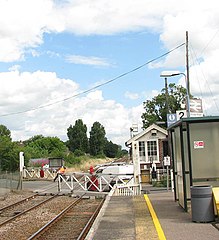
English: Eccles Road Station - opening of the crossing gates A train has just passed and the signalman has come out of the signal box in order to open the crossing gates on Station Road where the first of the waiting cars can be seen crossing the railway tracks.
Eccles Road railway station is served by local services operated by East Midlands Trains and National Express East Anglia running from Norwich to Peterborough and Cambridge. The station is unstaffed and has two platforms adjacent to a level crossing which is manually controlled. The staffed ex-GER (Great Eastern Railway) signal box > https://www.geograph.org.uk/photo/1399004 is located across the road from the west-bound platform. The old village of Eccles was abandoned and only St Mary's church > https://www.geograph.org.uk/photo/1399018 still stands on the site. The new village was built by the railway station. |
| Date | |
| Source | From geograph.org.uk |
| Author | Evelyn Simak |
| Attribution (required by the license) | Evelyn Simak / Eccles Road Station - opening of the crossing gates / |
| Camera location | | View this and other nearby images on: OpenStreetMap |
|---|
_heading:45.00&language=en)
| Object location | | View this and other nearby images on: OpenStreetMap |
|---|
_heading:45.00&language=en)
Licensing
[edit]

|
This image was taken from the Geograph project collection. See this photograph's page on the Geograph website for the photographer's contact details. The copyright on this image is owned by Evelyn Simak and is licensed for reuse under the Creative Commons Attribution-ShareAlike 2.0 license.
|
This file is licensed under the Creative Commons Attribution-Share Alike 2.0 Generic license.
Attribution: Evelyn Simak
- You are free:
- to share – to copy, distribute and transmit the work
- to remix – to adapt the work
- Under the following conditions:
- attribution – You must give appropriate credit, provide a link to the license, and indicate if changes were made. You may do so in any reasonable manner, but not in any way that suggests the licensor endorses you or your use.
- share alike – If you remix, transform, or build upon the material, you must distribute your contributions under the same or compatible license as the original.
File history
Click on a date/time to view the file as it appeared at that time.
| Date/Time | Thumbnail | Dimensions | User | Comment | |
|---|---|---|---|---|---|
| current | 21:48, 28 February 2011 | | 585 × 640 (97 KB) | GeographBot (talk | contribs) | == {{int:filedesc}} == {{Information |description={{en|1=Eccles Road Station - opening of the crossing gates A train has just passed and the signalman has come out of the signal box in order to open the crossing gates on Station Road where the first of th |
You cannot overwrite this file.
File usage on Commons
There are no pages that use this file.