File:Eastern Lesser Antilles (Barbuda to Grenada) satellite image.jpg
From Wikimedia Commons, the free media repository
Jump to navigation
Jump to search

Size of this preview: 450 × 600 pixels. Other resolutions: 180 × 240 pixels | 360 × 480 pixels | 576 × 768 pixels | 768 × 1,024 pixels | 2,400 × 3,200 pixels.
Original file (2,400 × 3,200 pixels, file size: 1.1 MB, MIME type: image/jpeg)
File information
Structured data
Captions
Captions
Add a one-line explanation of what this file represents
Summary
[edit]| DescriptionEastern Lesser Antilles (Barbuda to Grenada) satellite image.jpg |
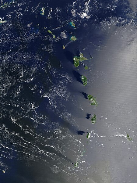
English: Original image caption: The Lesser Antilles island chain is centered in this true-color Moderate Resolution Imaging Spectroradiometer (MODIS) image from September 20, 2002. From bottom to top through the center are Grenada, St. Vincent (with Barbados to its east), St. Lucia, Fort-de-France, Dominica, Guadeloupe, Montserrat (slightly west of center line), Antigua, and Barbuda. The Lesser Antilles are part of a chain of islands that runs between the tip of Florida and northern South America in the Caribbean Sea. On Montserrat, the thermal signature (marked in red) could be from the Soufriere Hills Volcano.
Deutsch: Echtfarben-Aufnahme der östlichen Inselkette der Kleinen Antillen, aufgenommen am 20. September 2002 vom Moderate-Resolution Imaging Spectroradiometer (MODIS) des Satelliten Terra. Von unten nach oben sind das Grenada, St. Vincent (mit Barbados rechts daneben), St. Lucia, Martinique, Dominica, Guadeloupe, Montserrat (die kleine, etwas nach links abgesetzte Insel), Antigua und Barbuda. Die Kleinen Antillen sind Teil einer Inselkette, die sich vom Golf von Mexiko in einem weiten Bogen bis an den nordwestlichen Schelf Südamerikas zieht. Die thermische Signatur auf Montserrat (rot markiert) könnte vom Vulkan Soufrière Hills stammen. |
| Date | |
| Source | NASA Visible Earth: Lesser Antilles |
| Author | Jacques Descloitres, MODIS Rapid Response Team, NASA/GSFC |
Licensing
[edit]| Public domainPublic domainfalsefalse |
| This file is in the public domain in the United States because it was solely created by NASA. NASA copyright policy states that "NASA material is not protected by copyright unless noted". (See Template:PD-USGov, NASA copyright policy page or JPL Image Use Policy.) |  | |
 |
Warnings:
|
File history
Click on a date/time to view the file as it appeared at that time.
| Date/Time | Thumbnail | Dimensions | User | Comment | |
|---|---|---|---|---|---|
| current | 22:13, 26 January 2017 |  | 2,400 × 3,200 (1.1 MB) | Gretarsson (talk | contribs) | {{Information |Description ={{en|1=Original image caption: ''The Lesser Antilles island chain is centered in this true-color Moderate Resolution Imaging Spectroradiometer (MODIS) image from September 20, 2002. From bottom to top through the center a... |
You cannot overwrite this file.
File usage on Commons
The following page uses this file:
File usage on other wikis
The following other wikis use this file:
- Usage on de.wikipedia.org
- Usage on ka.wikipedia.org