File:Easter Oakenhead - geograph.org.uk - 1085608.jpg
Jump to navigation
Jump to search
No higher resolution available.
Easter_Oakenhead_-_geograph.org.uk_-_1085608.jpg (640 × 427 pixels, file size: 281 KB, MIME type: image/jpeg)
Captions
Captions
Add a one-line explanation of what this file represents
Summary
[edit]
| Description |
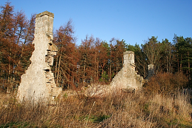
English: Easter Oakenhead There is something curious about the name of this ruined farm. On the 1874 Ordnance Survey map, and on all subsequent OS maps until 1982, it is marked as Easter Oakenhead. On the current maps, however, it is named Coral Peel, and there is a record of an application to build an extension at Coral Peel in 1971. The buildings here look too ruinous to have been occupied as recently as the 1970s, and there is no sign that the extension was ever built. |
| Date | |
| Source | From geograph.org.uk |
| Author | Anne Burgess |
| Attribution (required by the license) | Anne Burgess / Easter Oakenhead / |
| Camera location | | View this and other nearby images on: OpenStreetMap |
|---|
_heading:0.00&language=en)
| Object location | | View this and other nearby images on: OpenStreetMap |
|---|
_heading:0.00&language=en)
Licensing
[edit]

|
This image was taken from the Geograph project collection. See this photograph's page on the Geograph website for the photographer's contact details. The copyright on this image is owned by Anne Burgess and is licensed for reuse under the Creative Commons Attribution-ShareAlike 2.0 license.
|
This file is licensed under the Creative Commons Attribution-Share Alike 2.0 Generic license.
Attribution: Anne Burgess
- You are free:
- to share – to copy, distribute and transmit the work
- to remix – to adapt the work
- Under the following conditions:
- attribution – You must give appropriate credit, provide a link to the license, and indicate if changes were made. You may do so in any reasonable manner, but not in any way that suggests the licensor endorses you or your use.
- share alike – If you remix, transform, or build upon the material, you must distribute your contributions under the same or compatible license as the original.
File history
Click on a date/time to view the file as it appeared at that time.
| Date/Time | Thumbnail | Dimensions | User | Comment | |
|---|---|---|---|---|---|
| current | 10:32, 24 February 2011 | | 640 × 427 (281 KB) | GeographBot (talk | contribs) | == {{int:filedesc}} == {{Information |description={{en|1=Easter Oakenhead There is something curious about the name of this ruined farm. On the 1874 Ordnance Survey map, and on all subsequent OS maps until 1982, it is marked as Easter Oakenhead. On the cu |
You cannot overwrite this file.
File usage on Commons
There are no pages that use this file.