File:East Wallabi Island.jpg
Jump to navigation
Jump to search

Size of this preview: 730 × 600 pixels. Other resolutions: 292 × 240 pixels | 584 × 480 pixels | 935 × 768 pixels | 1,111 × 913 pixels.
Original file (1,111 × 913 pixels, file size: 51 KB, MIME type: image/jpeg)
Captions
Captions
Add a one-line explanation of what this file represents
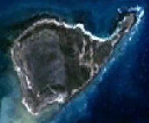
| Description | This is a satellite image of East Wallabi Island in the Houtman Abrolhos. | |||
| Date | Created on 2007-11-21; not sure when the satellite image was collected. | |||
| Source | It was made with NASA World Wind using Landsat 7 data. | |||
| Author | It was created by Hesperian. Any IP involved in the creation of this image is released into the public domain. | |||
| Permission (Reusing this file) |
|

File history
Click on a date/time to view the file as it appeared at that time.
| Date/Time | Thumbnail | Dimensions | User | Comment | |
|---|---|---|---|---|---|
| current | 11:40, 21 November 2007 | | 1,111 × 913 (51 KB) | Hesperian (talk | contribs) | {{Information |Description=This is a satellite image of East Wallabi Island in the Houtman Abrolhos. |Source=It was made with NASA World Wind using Landsat 7 data. |Date=Created on 2007-11-21; not sure when the satellite image was collected. |Aut |
You cannot overwrite this file.
File usage on Commons
There are no pages that use this file.
File usage on other wikis
The following other wikis use this file:
- Usage on arz.wikipedia.org
- Usage on ceb.wikipedia.org
- Usage on en.wikipedia.org
- Usage on it.wikipedia.org
- Usage on sv.wikipedia.org
- Usage on www.wikidata.org