File:Earth wall towards Knockmealdown - geograph.org.uk - 1154339.jpg
Jump to navigation
Jump to search
Size of this preview: 450 × 600 pixels. Other resolutions: 180 × 240 pixels | 480 × 640 pixels.
Original file (480 × 640 pixels, file size: 62 KB, MIME type: image/jpeg)
Captions
Captions
Add a one-line explanation of what this file represents
Summary
[edit]
| Description |
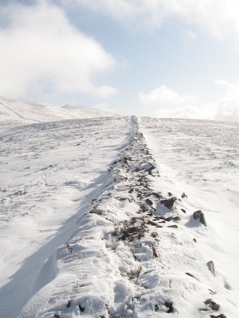
English: Earth wall towards Knockmealdown In Summer this earth wall is practically ignored by hikers whose preference is to walk on more level and worn ground to the left of it. However after snowfall, hikers find the earth wall an invaluable track towards the peak as it provides perfect direction not to mention a fairly drift free path to their destination.
This earth wall (ditch) which was man made denotes the border between counties Waterford and Tipperary. |
| Date | |
| Source | From geograph.org.uk |
| Author | Bryan Conlon |
| Attribution (required by the license) | Bryan Conlon / Earth wall towards Knockmealdown / |
| Camera location | | View this and other nearby images on: OpenStreetMap |
|---|
_heading:135.00&language=en)
| Object location | | View this and other nearby images on: OpenStreetMap |
|---|
_heading:135.00&language=en)
Licensing
[edit]

|
This image was taken from the Geograph project collection. See this photograph's page on the Geograph website for the photographer's contact details. The copyright on this image is owned by Bryan Conlon and is licensed for reuse under the Creative Commons Attribution-ShareAlike 2.0 license.
|
This file is licensed under the Creative Commons Attribution-Share Alike 2.0 Generic license.
Attribution: Bryan Conlon
- You are free:
- to share – to copy, distribute and transmit the work
- to remix – to adapt the work
- Under the following conditions:
- attribution – You must give appropriate credit, provide a link to the license, and indicate if changes were made. You may do so in any reasonable manner, but not in any way that suggests the licensor endorses you or your use.
- share alike – If you remix, transform, or build upon the material, you must distribute your contributions under the same or compatible license as the original.
File history
Click on a date/time to view the file as it appeared at that time.
| Date/Time | Thumbnail | Dimensions | User | Comment | |
|---|---|---|---|---|---|
| current | 10:06, 25 February 2011 | | 480 × 640 (62 KB) | GeographBot (talk | contribs) | == {{int:filedesc}} == {{Information |description={{en|1=Earth wall towards Knockmealdown In Summer this earth wall is practically ignored by hikers whose preference is to walk on more level and worn ground to the left of it. However after snowfall, hike |
You cannot overwrite this file.
File usage on Commons
There are no pages that use this file.