File:Earth from Space- Tashkent, Uzbekistan ESA24941666.jpg

Original file (5,499 × 4,720 pixels, file size: 6.05 MB, MIME type: image/jpeg)
Captions
Captions
Summary
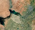
[edit]| Description |
English: The Copernicus Sentinel-2 mission takes us over Tashkent, the capital city of Uzbekistan. Zoom in to explore this image at its full 10 m resolution or click on the circles to learn more. Visible as the grey area in the top right of the image, Tashkent is the largest city in Central Asia. It lies in northeast Uzbekistan, near the border with Kazakhstan. The city is situated in the Chirchiq River valley. Vast agricultural fields dominate the image, particularly at the bottom. Cotton is the chief crop in this region, but wheat, rice, jute, melons and vegetables are also grown. The dark green body of water in the centre of the image is the Shardara Reservoir, an artificial lake located entirely within Kazakhstan. Along the edges of the lighter patch of cultivated land, visible south of the reservoir, runs the border between Kazakhstan and Uzbekistan. The lighter colours in the reservoir indicate the presence of sediment. The reservoir, which is used for irrigation, is the result of the Chardara dam – visible on the northwest bank. It is fed by the Syr Darya River, which enters the basin from southeast and flows northwest along the green strip of agricultural fields in the upper part of the image, within the surrounding desert. West of the river lies the Kyzylkum Desert, the 15th largest desert in the world. The Aydar Lake is immediately south. It is part of the artificial Aydar-Arnasay system of lakes, which, covering a total area of 4000 sq km, constitutes the largest reservoir in Uzbekistan. Copernicus Sentinel-2 is designed to provide images that can be used to distinguish between different crop types and accurately monitor plant growth. The mission’s frequent revisits over the same area and high spatial resolution also allow changes in inland water bodies to be closely monitored. |
| Date | 23 June 2023 (upload date) |
| Source | Earth from Space: Tashkent, Uzbekistan |
| Author | European Space Agency |
| Other versions |
|
| Activity | Observing the Earth |
| Mission | Sentinel-2 |
| Set | Earth from Space image collection |
| System | Copernicus |
Licensing
[edit]

|
This image contains data from a satellite in the Copernicus Programme, such as Sentinel-1, Sentinel-2 or Sentinel-3. Attribution is required when using this image.
Attribution: Contains modified Copernicus Sentinel data 2023
The use of Copernicus Sentinel Data is regulated under EU law (Commission Delegated Regulation (EU) No 1159/2013 and Regulation (EU) No 377/2014). Relevant excerpts:
Free access shall be given to GMES dedicated data [...] made available through GMES dissemination platforms [...].
Access to GMES dedicated data [...] shall be given for the purpose of the following use in so far as it is lawful:
GMES dedicated data [...] may be used worldwide without limitations in time.
GMES dedicated data and GMES service information are provided to users without any express or implied warranty, including as regards quality and suitability for any purpose. |
This media was created by the European Space Agency (ESA).
Where expressly so stated, images or videos are covered by the Creative Commons Attribution-ShareAlike 3.0 IGO (CC BY-SA 3.0 IGO) licence, ESA being an Intergovernmental Organisation (IGO), as defined by the CC BY-SA 3.0 IGO licence. The user is allowed under the terms and conditions of the CC BY-SA 3.0 IGO license to Reproduce, Distribute and Publicly Perform the ESA images and videos released under CC BY-SA 3.0 IGO licence and the Adaptations thereof, without further explicit permission being necessary, for as long as the user complies with the conditions and restrictions set forth in the CC BY-SA 3.0 IGO licence, these including that:
See the ESA Creative Commons copyright notice for complete information, and this article for additional details.
|
 | |
This file is licensed under the Creative Commons Attribution-ShareAlike 3.0 IGO license. Attribution: ESA, CC BY-SA IGO 3.0
| ||
File history
Click on a date/time to view the file as it appeared at that time.
| Date/Time | Thumbnail | Dimensions | User | Comment | |
|---|---|---|---|---|---|
| current | 06:04, 24 June 2023 | | 5,499 × 4,720 (6.05 MB) | OptimusPrimeBot (talk | contribs) | #Spacemedia - Upload of https://www.esa.int/var/esa/storage/images/esa_multimedia/images/2023/06/earth_from_space_tashkent_uzbekistan/24941656-1-eng-GB/Earth_from_Space_Tashkent_Uzbekistan.jpg via Commons:Spacemedia |
You cannot overwrite this file.
File usage on Commons
The following page uses this file: