File:Earth from Space- Poyang Lake, China ESA24732087.jpeg
Original file (1,565 × 2,446 pixels, file size: 2.4 MB, MIME type: image/jpeg)
Captions
Captions
Summary
[edit]
| Description |
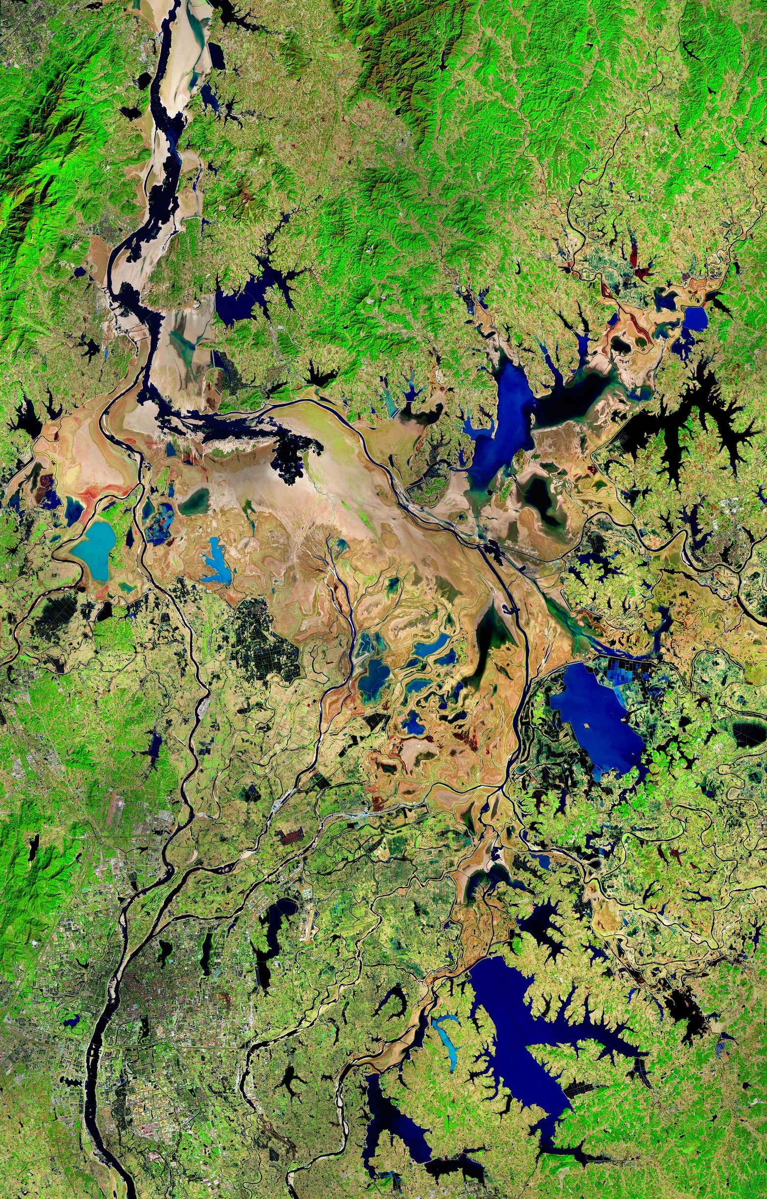
English: This Copernicus Sentinel-2 image shows Poyang Lake in China’s Jiangxi Province during winter. Zoom in to explore this image at its full resolution or click on the circles to learn more about the features in it. In summer, Poyang Lake is China’s largest freshwater body, but in the dry season, it shrinks to less than a third of its former size. As clearly visible in this image captured on 31 January 2023, the receding waters leave behind a system of wetlands and mudflats, which are an important habitat for migratory waterfowl. Poyang is one of China’s most important rice-producing areas, although local inhabitants must cope with massive seasonal changes in water level, topped by regular severe floods. Satellites have been used to monitor the evolution of the lake, as an improved understanding of Poyang Lake's annual dynamics could help with flood mitigation. This false-colour image combines both infrared and visible light. This combination allows us to easily identify water bodies, distinguish crop types and differentiate vegetation conditions. As water absorbs infrared, shallow waters with a high concentration of sediments are shown in various shades of blue, while rivers appear in black. The Gan River, visible in the bottom-left corner, flows northward into Poyang Lake through the city of Nanchang, capital of the Jiangxi Province. Exposed dry soil in the lake’s basin appears in light brown. In contrast, agricultural areas and forests stand out in vibrant tones of green. In the lower part of the image, a dense system of canals feeds the cultivated fields, that can be identified as rectangular shapes nestled within the canals. Some of the fields appear in shades of blue, meaning they are waterlogged. |
| Date | 3 March 2023 (upload date) |
| Source | Earth from Space: Poyang Lake, China |
| Author | European Space Agency |
| Other versions |
|
| Activity | Observing the Earth |
| Mission | Sentinel-2 |
| Set | Earth from Space image collection |
| System | Copernicus |
Licensing
[edit]

|
This image contains data from a satellite in the Copernicus Programme, such as Sentinel-1, Sentinel-2 or Sentinel-3. Attribution is required when using this image.
Attribution: Contains modified Copernicus Sentinel data 2023
The use of Copernicus Sentinel Data is regulated under EU law (Commission Delegated Regulation (EU) No 1159/2013 and Regulation (EU) No 377/2014). Relevant excerpts:
Free access shall be given to GMES dedicated data [...] made available through GMES dissemination platforms [...].
Access to GMES dedicated data [...] shall be given for the purpose of the following use in so far as it is lawful:
GMES dedicated data [...] may be used worldwide without limitations in time.
GMES dedicated data and GMES service information are provided to users without any express or implied warranty, including as regards quality and suitability for any purpose. |
This media was created by the European Space Agency (ESA).
Where expressly so stated, images or videos are covered by the Creative Commons Attribution-ShareAlike 3.0 IGO (CC BY-SA 3.0 IGO) licence, ESA being an Intergovernmental Organisation (IGO), as defined by the CC BY-SA 3.0 IGO licence. The user is allowed under the terms and conditions of the CC BY-SA 3.0 IGO license to Reproduce, Distribute and Publicly Perform the ESA images and videos released under CC BY-SA 3.0 IGO licence and the Adaptations thereof, without further explicit permission being necessary, for as long as the user complies with the conditions and restrictions set forth in the CC BY-SA 3.0 IGO licence, these including that:
See the ESA Creative Commons copyright notice for complete information, and this article for additional details.
|
 | |
This file is licensed under the Creative Commons Attribution-ShareAlike 3.0 IGO license. Attribution: ESA, CC BY-SA IGO 3.0
| ||
File history
Click on a date/time to view the file as it appeared at that time.
| Date/Time | Thumbnail | Dimensions | User | Comment | |
|---|---|---|---|---|---|
| current | 17:58, 3 March 2023 | | 1,565 × 2,446 (2.4 MB) | OptimusPrimeBot (talk | contribs) | #Spacemedia - Upload of https://www.esa.int/var/esa/storage/images/esa_multimedia/images/2023/03/earth_from_space_poyang_lake_china/24732076-2-eng-GB/Earth_from_Space_Poyang_Lake_China.jpg via Commons:Spacemedia |
You cannot overwrite this file.
File usage on Commons
The following page uses this file: