File:Earth from Space- New Zealand’s North Island ESA497295.jpg

Original file (4,318 × 6,045 pixels, file size: 7.45 MB, MIME type: image/jpeg)
Captions
Captions
Summary
[edit]| Description |
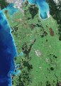
English: Captured on 7 May 2024, this Copernicus Sentinel-2 image shows part of New Zealand’s North Island. Zoom in to explore this image at its full 10 m resolution or click on the circles to learn more. New Zealand lies in the South Pacific Ocean and comprises two major islands – North and South – and a number of smaller islands. Much of North Island’s terrain in this image is dominated by lush vegetation, with darker green areas denoting dense forested zones. Urban centres appear in grey. Towards the top of the image, the city of Auckland can be seen as a large, grey area adjacent to the Hauraki Gulf to the east and the Manukau Harbour to the west. Auckland is the country’s most populous city and its largest port. A focal point for transportation, the city is also served by New Zealand’s leading international airport, which can be spotted in the centre of Manukau Harbour. Moving south, the largest grey area in the middle of the image is Hamilton, one of the country’s most important inland centres. It straddles the Waikato River, the longest river in New Zealand, which can be seen as a dark, winding line across the bottom right of the image, bisecting Hamilton into two nearly symmetrical parts. As it winds its course, the Waikato meanders through a patchwork of agricultural fields that cover the plain between Auckland and Hamilton. The green and brown hues of the fields shift according to the crop type and their various stages of growth. Before entering the Tasman Sea, south of Auckland, the Waikato River forms an estuary, which feeds a network of marshes and creates numerous small islands. On the coast, bright, turquoise colours in the Tasman Sea suggest the presence of sediment being carried into the ocean by river discharge. The swirls in the sea show how the currents transport sediment. A number of lakes and wetlands can be spotted near the centre of the image, including the Whangamarino Wetland, an extensive mosaic of swamps and bogs, visible as a dark brown area east of the Waikato River. The Kopuatai Peat Dome, the largest, unaltered peat bog in New Zealand, is clear to see as the brown, elongated feature just south of the Hauraki Gulf. |
| Date | 17 May 2024 (upload date) |
| Source | Earth from Space: New Zealand’s North Island |
| Author | European Space Agency |
| Other versions |
|
| Activity | Observing the Earth |
| Mission | Sentinel-2 |
| Set | Earth from Space image collection |
| System | Copernicus |
Licensing
[edit]

|
This image contains data from a satellite in the Copernicus Programme, such as Sentinel-1, Sentinel-2 or Sentinel-3. Attribution is required when using this image.
Attribution: Contains modified Copernicus Sentinel data 2024
The use of Copernicus Sentinel Data is regulated under EU law (Commission Delegated Regulation (EU) No 1159/2013 and Regulation (EU) No 377/2014). Relevant excerpts:
Free access shall be given to GMES dedicated data [...] made available through GMES dissemination platforms [...].
Access to GMES dedicated data [...] shall be given for the purpose of the following use in so far as it is lawful:
GMES dedicated data [...] may be used worldwide without limitations in time.
GMES dedicated data and GMES service information are provided to users without any express or implied warranty, including as regards quality and suitability for any purpose. |
This media was created by the European Space Agency (ESA).
Where expressly so stated, images or videos are covered by the Creative Commons Attribution-ShareAlike 3.0 IGO (CC BY-SA 3.0 IGO) licence, ESA being an Intergovernmental Organisation (IGO), as defined by the CC BY-SA 3.0 IGO licence. The user is allowed under the terms and conditions of the CC BY-SA 3.0 IGO license to Reproduce, Distribute and Publicly Perform the ESA images and videos released under CC BY-SA 3.0 IGO licence and the Adaptations thereof, without further explicit permission being necessary, for as long as the user complies with the conditions and restrictions set forth in the CC BY-SA 3.0 IGO licence, these including that:
See the ESA Creative Commons copyright notice for complete information, and this article for additional details.
|
 | |
This file is licensed under the Creative Commons Attribution-ShareAlike 3.0 IGO license. Attribution: ESA, CC BY-SA IGO 3.0
| ||
File history
Click on a date/time to view the file as it appeared at that time.
| Date/Time | Thumbnail | Dimensions | User | Comment | |
|---|---|---|---|---|---|
| current | 06:05, 18 May 2024 | | 4,318 × 6,045 (7.45 MB) | OptimusPrimeBot (talk | contribs) | #Spacemedia - Upload of https://www.esa.int/var/esa/storage/images/esa_multimedia/images/2024/05/earth_from_space_new_zealand_s_north_island/26082555-1-eng-GB/Earth_from_Space_New_Zealand_s_North_Island.jpg via Commons:Spacemedia |
You cannot overwrite this file.
File usage on Commons
The following page uses this file: