File:Early Medieval pin (FindID 872699).jpg
Jump to navigation
Jump to search
Size of this preview: 628 × 600 pixels. Other resolutions: 251 × 240 pixels | 502 × 480 pixels | 804 × 768 pixels | 1,072 × 1,024 pixels | 2,144 × 2,048 pixels | 3,316 × 3,168 pixels.
Original file (3,316 × 3,168 pixels, file size: 1.74 MB, MIME type: image/jpeg)
Captions
Captions
Add a one-line explanation of what this file represents
Summary
[edit].jpg&action=edit§ion=1)
| Early Medieval pin | |||
|---|---|---|---|
| Photographer |
The Portable Antiquities Scheme, Arwen Wood, 2017-11-01 15:08:57 |
||
| Title |
Early Medieval pin |
||
| Description |
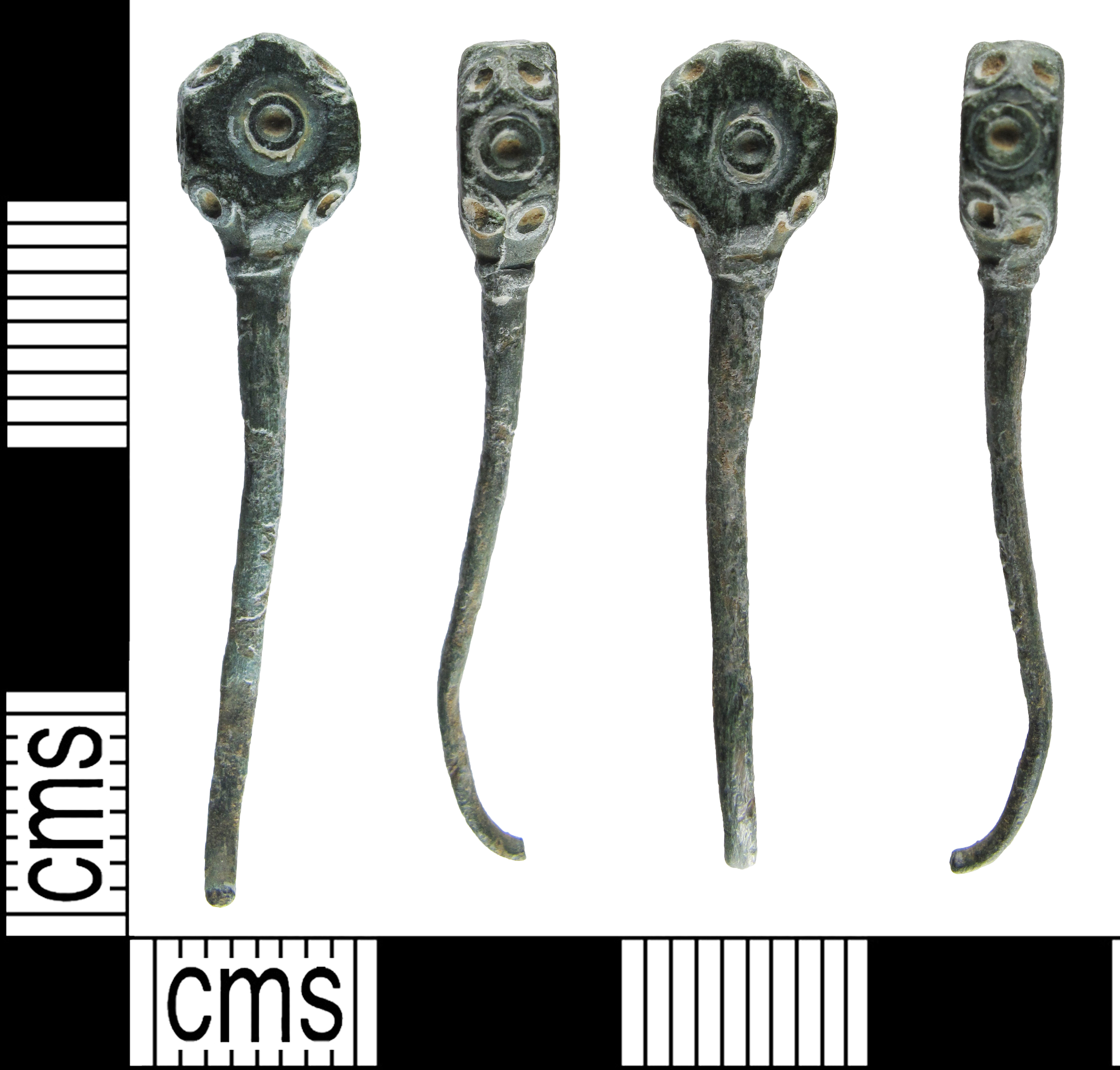
English: An incomplete early Anglo Saxon copper alloy pin dating from c.600-900 AD. The pin has a polyhedral shaped head, it is rectangular with the corners cut off, the sides are irregular rectangle and lozenge shapes. Each section has a raised ring and punched dot inside. Below the head is a worn raised collar, this is worn. The shaft decends from the base of the head, and narrows slightly, before terminating in a worn break. It is circular in cross section. The pin has a dark green patina, inside the recesses of the ring and dots is a light orangey brown colour. The pin measures 32.8mm in length, 6.8mm in width, 3.8mm in thickness, and weighs 1.40g.
The ring and dot decoration is similar to a pin shown in MacGregor and Bolick, page 186, number 31.10. This was found in a inhumation at Stanton Harcourt, which was dated to the 7th Century AD. |
||
| Depicted place | (County of findspot) Central Bedfordshire | ||
| Date | between 600 and 900 | ||
| Accession number |
FindID: 872699 Old ref: BUC-9DD9EC Filename: BUC9DD9EC2.jpg |
||
| Credit line |
|
||
| Source |
https://finds.org.uk/database/ajax/download/id/635573 Catalog: https://finds.org.uk/database/images/image/id/635573/recordtype/artefacts archive copy at the Wayback Machine Artefact: https://finds.org.uk/database/artefacts/record/id/872699 |
||
| Permission (Reusing this file) |
Attribution License | ||
| Object location | | View this and other nearby images on: OpenStreetMap |
|---|
.jpg¶ms=051.827400_N_-000.523260_E_globe:Earth_class:object_type:object__&language=en)
Licensing
[edit].jpg&action=edit§ion=2)
This file is licensed under the Creative Commons Attribution 2.0 Generic license.
Attribution: The Portable Antiquities Scheme
- You are free:
- to share – to copy, distribute and transmit the work
- to remix – to adapt the work
- Under the following conditions:
- attribution – You must give appropriate credit, provide a link to the license, and indicate if changes were made. You may do so in any reasonable manner, but not in any way that suggests the licensor endorses you or your use.
File history
Click on a date/time to view the file as it appeared at that time.
| Date/Time | Thumbnail | Dimensions | User | Comment | |
|---|---|---|---|---|---|
| current | 23:21, 6 December 2018 | | 3,316 × 3,168 (1.74 MB) | Fæ (talk | contribs) | Portable Antiquities Scheme, BUC, FindID: 872699, early medieval, page 710, batch count 12470 |
You cannot overwrite this file.
File usage on Commons
The following page uses this file:
.jpg)
.jpg&oldid=546425241)