File:Eaa2623 001 0002044 00020 k1.jpg
Jump to navigation
Jump to search

Size of this preview: 289 × 598 pixels. Other resolutions: 116 × 240 pixels | 232 × 480 pixels | 371 × 768 pixels | 1,198 × 2,480 pixels.
Original file (1,198 × 2,480 pixels, file size: 2.07 MB, MIME type: image/jpeg)
Captions
Captions
Add a one-line explanation of what this file represents
Other Parts of the map

2/2
Summary
[edit]
| Description |
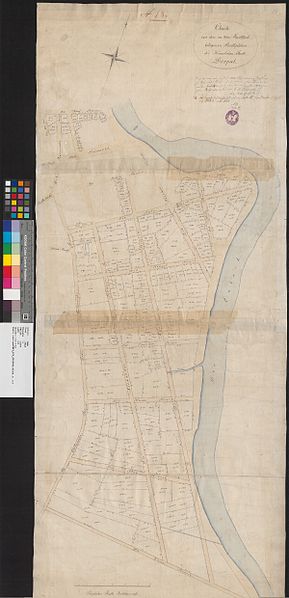
English: A map from Estonian National Archives with Reference code: EAA.2623.1.2044 sheet 20; 1/2 Eesti: Kaart Eesti Rahvusarhiivist Lähtekoodiga: EAA.2623.1.2044 leht 20; 1/2 |
| Date | |
| Source | http://www.ra.ee/kaardid/index.php/en/map/view?id=19756 |
| Author | Conrad Martin Sengbusch |
| Language | German |
| Map type | City Plan |
| Map sheet | Single sheet map |
| Map reproduction | Printed |
| Title | Deutsch: Charte von den im 2-ten Stadttheile belegenen Stadtsplätzen der Kaiserlichen Stadt Dorpat |
| Map scale | 1:1600 |
| Accession number | EAA.2623.1.2044 sheet 20 |
| Dimensions | 126 × 50 cm (49.6 × 19.6 in) |
| Medium | print on paper |
Licensing
[edit]
|
This work is in the public domain in its country of origin and other countries and areas where the copyright term is the author's life plus 70 years or fewer. | |
| This file has been identified as being free of known restrictions under copyright law, including all related and neighboring rights. | |
File history
Click on a date/time to view the file as it appeared at that time.
| Date/Time | Thumbnail | Dimensions | User | Comment | |
|---|---|---|---|---|---|
| current | 11:50, 27 November 2014 | | 1,198 × 2,480 (2.07 MB) | JLoide (talk | contribs) | User created page with UploadWizard |
You cannot overwrite this file.
File usage on Commons
The following 2 pages use this file: