File:EU members where more people in favor of the European Federation.png
Jump to navigation
Jump to search
Size of this preview: 718 × 600 pixels. Other resolutions: 288 × 240 pixels | 575 × 480 pixels | 920 × 768 pixels | 1,200 × 1,002 pixels.
Original file (1,200 × 1,002 pixels, file size: 455 KB, MIME type: image/png)
Captions
Captions
Add a one-line explanation of what this file represents

|
File:EU members and the UK by supranational federalism.svg is a vector version of this file. It should be used in place of this PNG file when not inferior.
File:EU members where more people in favor of the European Federation.png → File:EU members and the UK by supranational federalism.svg
For more information, see Help:SVG. |
 |
Summary
[edit]
| Description |
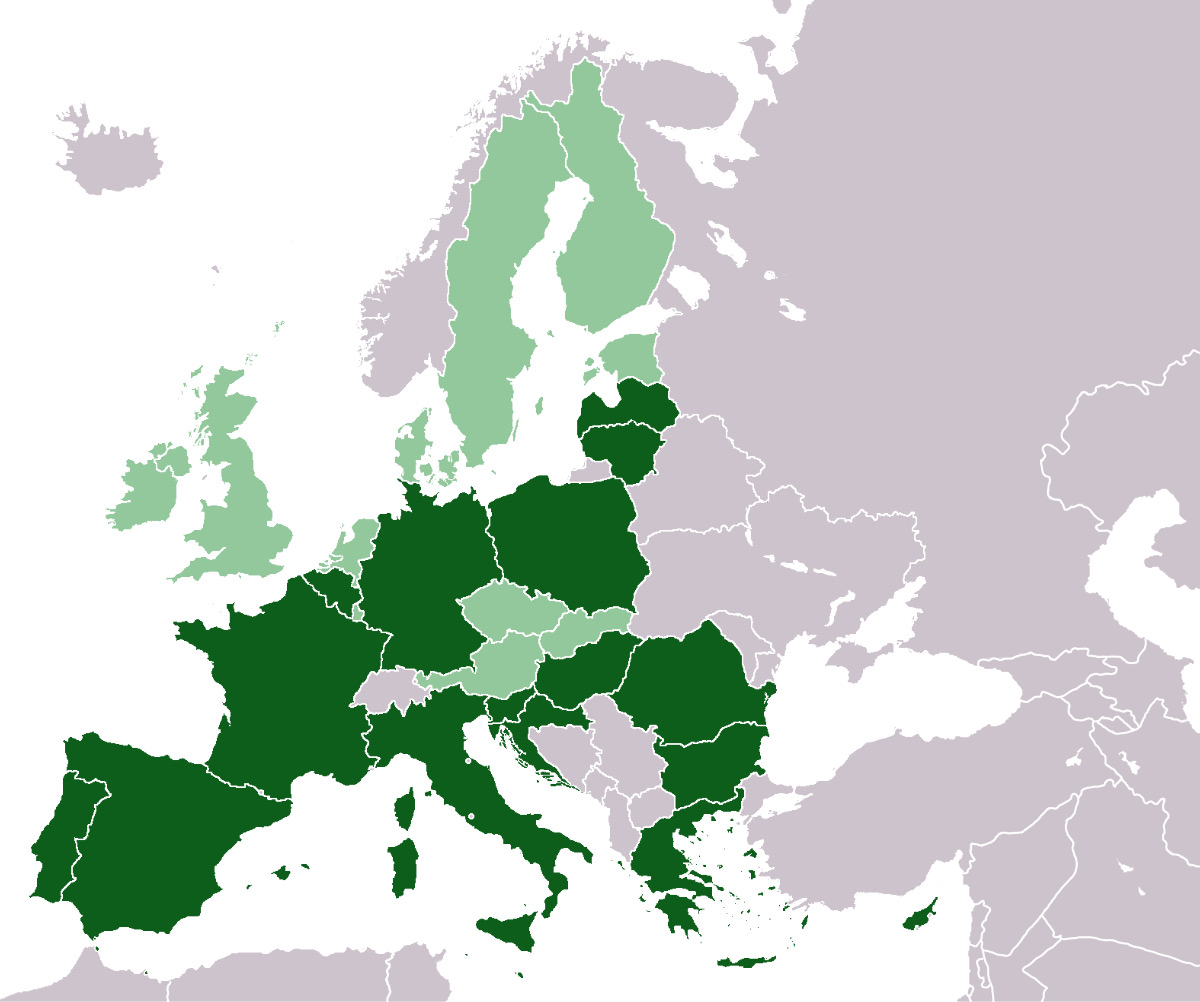
English: The EU members with more "federalists" than "anti-federalists" according to polls (Eurobarometer, Spring 2014, p.151). In the dark green countries more people are agree with the idea that "the EU should develop further into a federation of Nation-States” than disagree. |
| Date | |
| Source | Own work |
| Author | Zhitelew. Based on this blank map by its respective authors. |
Licensing
[edit]

|
Permission is granted to copy, distribute and/or modify this document under the terms of the GNU Free Documentation License, Version 1.2 or any later version published by the Free Software Foundation; with no Invariant Sections, no Front-Cover Texts, and no Back-Cover Texts. A copy of the license is included in the section entitled GNU Free Documentation License. |
| This file is licensed under the Creative Commons Attribution-Share Alike 3.0 Unported license. | ||
| ||
| This licensing tag was added to this file as part of the GFDL licensing update. |
File history
Click on a date/time to view the file as it appeared at that time.
| Date/Time | Thumbnail | Dimensions | User | Comment | |
|---|---|---|---|---|---|
| current | 12:53, 28 January 2023 | | 1,200 × 1,002 (455 KB) | Iktsokh (talk | contribs) | Updated |
| 01:49, 27 February 2021 |  | 1,236 × 1,245 (60 KB) | RickoTroanman22 (talk | contribs) | This was made in 2014, so it should be this map | |
| 08:41, 6 February 2021 |  | 1,236 × 1,245 (60 KB) | S. Abraev (talk | contribs) | United Kingdom withdrew from the European Union on 31 January 2020 | |
| 08:34, 22 November 2015 |  | 1,236 × 1,245 (60 KB) | Hibernian (talk | contribs) | Reverted to version as of 08:13, 22 November 2015 (UTC) | |
| 08:30, 22 November 2015 |  | 1,236 × 1,245 (60 KB) | Hibernian (talk | contribs) | Trying again to upload proper version | |
| 08:13, 22 November 2015 |  | 1,236 × 1,245 (60 KB) | Hibernian (talk | contribs) | Cleaned up the map, as the previous version didn't include any islands and it incorrectly included the Isle of Man as part of the EU. | |
| 07:35, 16 July 2015 |  | 1,236 × 1,245 (48 KB) | Zhitelew (talk | contribs) | User created page with UploadWizard |
You cannot overwrite this file.
File usage on Commons
The following page uses this file:
File usage on other wikis
The following other wikis use this file:
- Usage on ar.wikipedia.org
- Usage on ba.wikipedia.org
- Usage on cs.wikipedia.org
- Usage on en.wikipedia.org
- Usage on nl.wikipedia.org
- Usage on pl.wikipedia.org
- Usage on pt.wikipedia.org
- Usage on ru.wikipedia.org
- Usage on sl.wikipedia.org