File:EB 1911 Ptolemy's Map.png
Jump to navigation
Jump to search

Size of this preview: 800 × 442 pixels. Other resolutions: 320 × 177 pixels | 640 × 354 pixels | 1,024 × 566 pixels | 1,280 × 708 pixels | 2,560 × 1,416 pixels | 3,916 × 2,166 pixels.
Original file (3,916 × 2,166 pixels, file size: 3.86 MB, MIME type: image/png)
Captions
Captions
Add a one-line explanation of what this file represents
Summary
[edit]| Description |
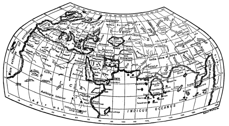
English: Caption: "Fig. 3.—Ptolemy's Map." A black-and-white map of the Inhabited World according to Ptolemy's 2nd-century Geography, done according to his 2nd projection and labelled in Latin. The treatment is somewhat irregular, calling Africa "Africa" instead of Ptolemy's Libya but using the Greekified "Thyle" for Thule; Ptolemy's confused central African river systems are mostly removed, as is the coastline connecting Cape Prasum in Libya to the land of the Sinae in southeast Asia. The Indian Ocean is given by Ptolemy as a number of landlocked seas but presented here as a single "Indicum Oceanum". For discussion of the errors inherent in the original—such as the unexpected misplacement of Carthage and the north African coast—see the EB’s article on "Ptolemy". The caption describes it as "Fig. 3", but it is actually the 4th figure in the article. |
| Date | circa 1911 |
| Source | "Map" in the Encyclopaedia Britannica, 11th ed., Vol. XVII, p. 636. |
| Author | Credited to Emery Walker |
| Other versions |
|

Licensing
[edit]
This media file is in the public domain in the United States. This applies to U.S. works where the copyright has expired, often because its first publication occurred prior to January 1, 1929, and if not then due to lack of notice or renewal. See this page for further explanation.
|
 | |
 |
This image might not be in the public domain outside of the United States; this especially applies in the countries and areas that do not apply the rule of the shorter term for US works, such as Canada, Mainland China (not Hong Kong or Macao), Germany, Mexico, and Switzerland. The creator and year of publication are essential information and must be provided. See Wikipedia:Public domain and Wikipedia:Copyrights for more details.
|
| This image comes from the 13th edition of the Encyclopædia Britannica or earlier. The copyrights for that book have expired in the United States because the book was first published in the US with the publication occurring before January 1, 1929. As such, this image is in the public domain in the United States. |  |
| Annotations | This image is annotated: View the annotations at Commons |
File history
Click on a date/time to view the file as it appeared at that time.
| Date/Time | Thumbnail | Dimensions | User | Comment | |
|---|---|---|---|---|---|
| current | 08:49, 29 March 2015 | | 3,916 × 2,166 (3.86 MB) | LlywelynII (talk | contribs) | User created page with UploadWizard |
You cannot overwrite this file.
File usage on Commons
The following page uses this file:
File usage on other wikis
The following other wikis use this file:
- Usage on en.wikisource.org