File:Duxford Bailey Bridge - geograph.org.uk - 4642436.jpg

Original file (1,600 × 1,200 pixels, file size: 656 KB, MIME type: image/jpeg)
Captions
Captions
Summary
| Description |
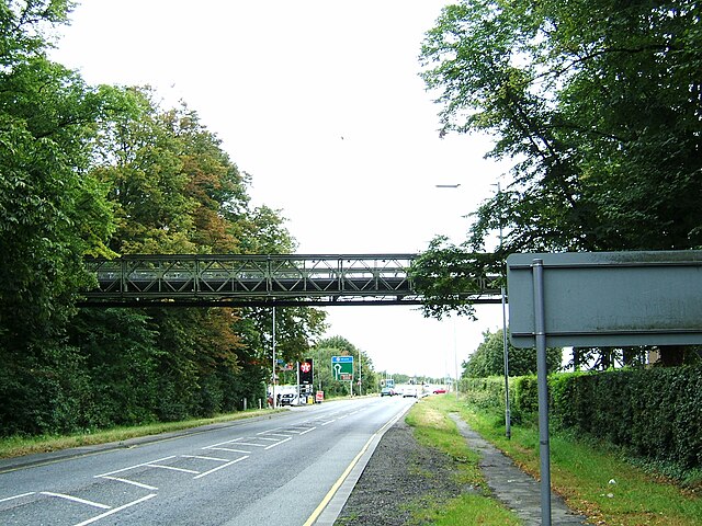
English: Duxford Mabey Compact 200 Bridge |
| Depicts | military facility, bridge, Whittlesford |
| Date |
|
| Source |
Geograph Britain and Ireland |
| Author |
pablo haworth |
| Place of creation | Duxford |
| Camera location | | View this and other nearby images on: OpenStreetMap |
|---|
| Object location | | View this and other nearby images on: OpenStreetMap |
|---|
Licensing

|
This image was taken from the Geograph project collection. See this photograph's page on the Geograph website for the photographer's contact details. The copyright on this image is owned by pablo haworth
|
- You are free:
- to share – to copy, distribute and transmit the work
- to remix – to adapt the work
- Under the following conditions:
- attribution – You must give appropriate credit, provide a link to the license, and indicate if changes were made. You may do so in any reasonable manner, but not in any way that suggests the licensor endorses you or your use.
- share alike – If you remix, transform, or build upon the material, you must distribute your contributions under the same or compatible license as the original.
Imperial War Museum Duxford Access Bridge, UK : IWM Duxford is a former RAF fighter station dating back to WW1, with a long and distinguished history, particularly famous for its role in the Battle of Britain in 1940. Today it is one of the world’s leading and most popular aviation museums, housing some 200 aircraft ranging from ‘pioneering’ biplanes to modern day jets.
The original access bridge, installed in 1984 and used by vehicles and pedestrians to cross the main A505 trunk road in Duxford, needed replacing and this prompted the museum to approach Mabey Bridge. The central span of the bridge crosses the main road, and the ramp spans and the two piers sit on IWM land, which is in a conservation area. The initial enquiry was simply for background information on the original C100 bridge and Mabey Bridge provided the relevant historical and technical information. IWM’s own consulting engineers then conducted a comprehensive survey of the bridge and recommended that the old bridge was replaced, keeping the two piers, which were to be re-used.
Mabey Bridge’s Digital Engineering Department supported the scoping work using the latest advances in digital design and imaging technology. Armed with this capability the Mabey Bridge Site Advisor, Steve Morgan, was able to present the IWM Team with the optimal solution. A three span Compact 200™, 58.878m x 3.15m with anti-skid decking was specified. It is the natural successor to the older Compact 100 structure, and also conforms to the planning constraints which dictated a ‘like for like’ replacement. A bespoke parapet rail system, powder coated green, was also specified and fitted across the entire length of bridge.
File history
Click on a date/time to view the file as it appeared at that time.
| Date/Time | Thumbnail | Dimensions | User | Comment | |
|---|---|---|---|---|---|
| current | 03:25, 16 April 2023 | | 1,600 × 1,200 (656 KB) | GeographBot (talk | contribs) | Uploading geograph.org.uk image from https://www.geograph.org.uk/photo/4642436 |
You cannot overwrite this file.
File usage on Commons
There are no pages that use this file.