File:Durrani Empire 1747 1862 AD.png

Original file (832 × 650 pixels, file size: 105 KB, MIME type: image/png)
Captions
Captions
| DescriptionDurrani Empire 1747 1862 AD.png |
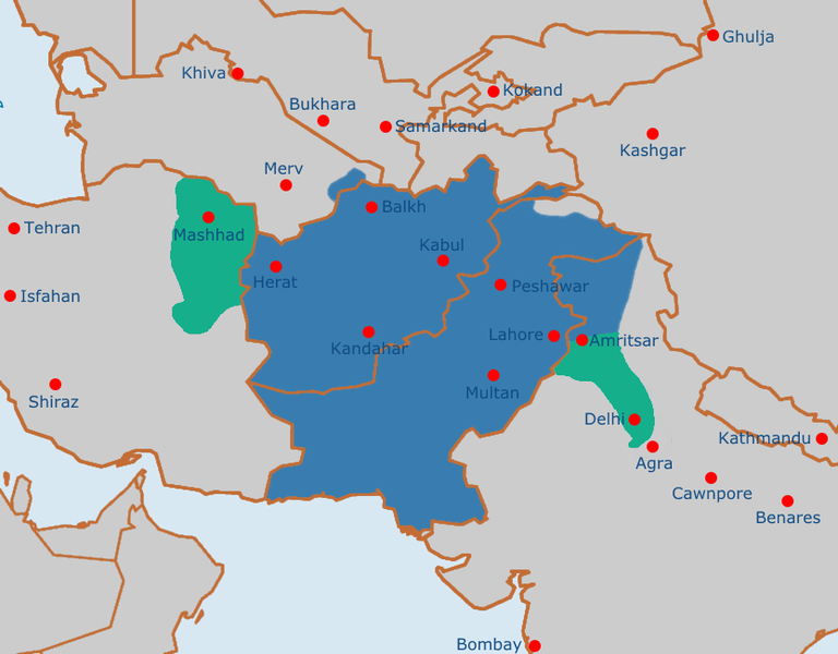
English: Map of the Afghan Durrani Empire at its greatest extent, circa late 1750s. In green is de facto (vassal) control. |
| Date | |
| Source | https://en.wikipedia.org/wiki/File:Safavid_Empire_1501_1722_AD.png |
| Author | Arab Hafez and edited by me. |
| Public domainPublic domainfalsefalse |
This file is in the public domain because Released into the public domain by the author.
|
File history
Click on a date/time to view the file as it appeared at that time.
| Date/Time | Thumbnail | Dimensions | User | Comment | |
|---|---|---|---|---|---|
| current | 11:51, 4 August 2021 |  | 832 × 650 (105 KB) | Weaveravel (talk | contribs) | De facto/vessel control and corrected Mashhad/Khorasan |
| 11:39, 4 August 2021 |  | 832 × 650 (108 KB) | Weaveravel (talk | contribs) | Improved map layout and scale, added Delhi territory (as de facto control), fixed cities geographical positions | |
| 18:54, 26 July 2021 |  | 1,415 × 958 (205 KB) | Weaveravel (talk | contribs) | Clearer, high quality map, more accurate labels and cities (denoting important ones) | |
| 14:27, 28 April 2013 |  | 620 × 429 (22 KB) | HistoryofIran (talk | contribs) | {{subst:Upload marker added by en.wp UW}} {{Information |Description = {{en|Map of the Durrani Empire at it's greatest extent.}} |Source = https://en.wikipedia.org/wiki/File:Safavid_Empire_1501_1722_AD.png |Date = 28. April 2013. |Author = Arab Hafez a... |
You cannot overwrite this file.
File usage on Commons
The following 7 pages use this file:
File usage on other wikis
The following other wikis use this file:
- Usage on ar.wikipedia.org
- Usage on ast.wikipedia.org
- Usage on azb.wikipedia.org
- Usage on az.wikipedia.org
- Usage on be.wikipedia.org
- Usage on bg.wikipedia.org
- Usage on bn.wikipedia.org
- Usage on bs.wikipedia.org
- Usage on ca.wikipedia.org
- Usage on cs.wikipedia.org
- Usage on de.wikipedia.org
- Usage on diq.wikipedia.org
- Usage on el.wikipedia.org
- Usage on en.wikipedia.org
- Usage on eo.wikipedia.org
- Usage on es.wikipedia.org
- Usage on et.wikipedia.org
- Usage on eu.wikipedia.org
- Usage on fa.wikipedia.org
- Usage on fi.wikipedia.org
- Usage on fr.wikipedia.org
- Usage on he.wikipedia.org
- Usage on hi.wikipedia.org
- Usage on hu.wikipedia.org
- Usage on hy.wikipedia.org
- Usage on it.wikipedia.org
- Usage on ka.wikipedia.org
- Usage on kn.wikipedia.org
- Usage on lt.wikipedia.org
- Usage on mn.wikipedia.org
- Usage on nl.wikipedia.org
- Usage on nn.wikipedia.org
- Usage on pt.wikipedia.org
- Usage on ru.wikipedia.org
- Usage on sk.wikipedia.org
- Usage on sv.wikipedia.org
- Usage on ta.wikipedia.org
- Usage on tg.wikipedia.org
View more global usage of this file.
Metadata
This file contains additional information such as Exif metadata which may have been added by the digital camera, scanner, or software program used to create or digitize it. If the file has been modified from its original state, some details such as the timestamp may not fully reflect those of the original file. The timestamp is only as accurate as the clock in the camera, and it may be completely wrong.
| Horizontal resolution | 37.79 dpc |
|---|---|
| Vertical resolution | 37.79 dpc |