File:Dunree Fort Rangefinder 2014 09 12.jpg
Jump to navigation
Jump to search
Size of this preview: 800 × 575 pixels. Other resolutions: 320 × 230 pixels | 640 × 460 pixels | 1,024 × 736 pixels | 1,280 × 920 pixels | 2,848 × 2,047 pixels.
Original file (2,848 × 2,047 pixels, file size: 3.96 MB, MIME type: image/jpeg)
Captions
Captions
Add a one-line explanation of what this file represents
Summary
| Description |
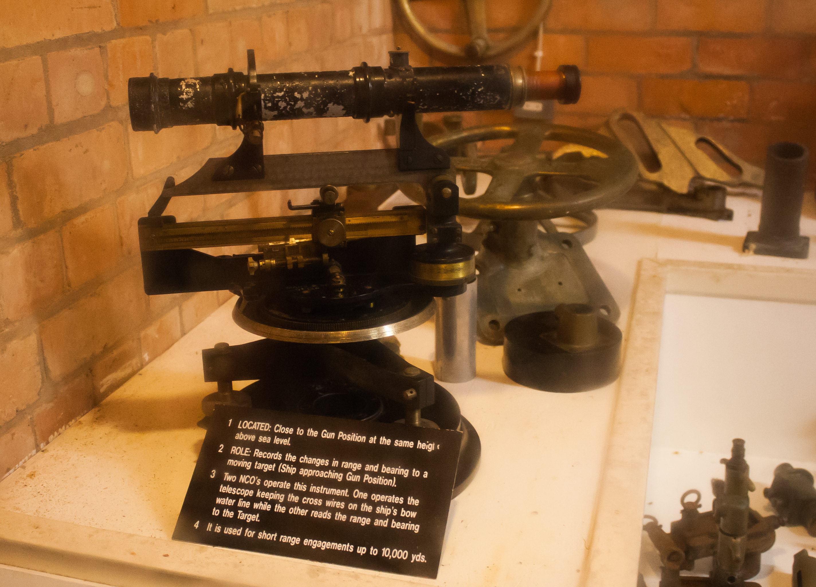
Fort Dunree, County Donegal, Ireland English: Rangefinder, originally located close to the position of the coastal defense gun and now exhibited in the underground bunker. The inscription reads:
|
| Date | |
| Source | Self-photographed |
| Author | Andreas F. Borchert |
| Reference | 2014/31298 |
|
|
Do not upload new revisions over this file version without my explicit consent. Instead, use the possibility to upload a new version under a new name and tag it as a derivative or extract of this file.
|

Licensing
Andreas F. Borchert, the copyright holder of this work, hereby publishes it under the following licenses:
This file is licensed under the Creative Commons Attribution-Share Alike 3.0 Germany license.
Attribution: Andreas F. Borchert
- You are free:
- to share – to copy, distribute and transmit the work
- to remix – to adapt the work
- Under the following conditions:
- attribution – You must give appropriate credit, provide a link to the license, and indicate if changes were made. You may do so in any reasonable manner, but not in any way that suggests the licensor endorses you or your use.
- share alike – If you remix, transform, or build upon the material, you must distribute your contributions under the same or compatible license as the original.

This file is licensed under the Creative Commons Attribution-Share Alike Attribution-Share Alike 4.0 International, 3.0 Unported, 2.5 Generic, 2.0 Generic and 1.0 Generic license.
Attribution: Andreas F. Borchert
- You are free:
- to share – to copy, distribute and transmit the work
- to remix – to adapt the work
- Under the following conditions:
- attribution – You must give appropriate credit, provide a link to the license, and indicate if changes were made. You may do so in any reasonable manner, but not in any way that suggests the licensor endorses you or your use.
- share alike – If you remix, transform, or build upon the material, you must distribute your contributions under the same or compatible license as the original.

|
Permission is granted to copy, distribute and/or modify this document under the terms of the GNU Free Documentation License, Version 1.2 or any later version published by the Free Software Foundation; with no Invariant Sections, no Front-Cover Texts, and no Back-Cover Texts. A copy of the license is included in the section entitled GNU Free Documentation License. |
You may select the license of your choice.
File history
Click on a date/time to view the file as it appeared at that time.
| Date/Time | Thumbnail | Dimensions | User | Comment | |
|---|---|---|---|---|---|
| current | 09:24, 12 April 2015 | | 2,848 × 2,047 (3.96 MB) | AFBorchert (talk | contribs) | {{User:AFBorchert/Photo |Location=Fort Dunree, County Donegal, Ireland |Date=2014-09-12 |Description={{en|Rangefinder, originally located close to the position of the coastal defense gun and now exhibited in the underground bunker. The inscription read... |
You cannot overwrite this file.
File usage on Commons
There are no pages that use this file.