File:Dudynce - mapa 1852.jpg
Jump to navigation
Jump to search

Size of this preview: 698 × 599 pixels. Other resolutions: 280 × 240 pixels | 559 × 480 pixels | 895 × 768 pixels | 1,193 × 1,024 pixels | 1,477 × 1,268 pixels.
Original file (1,477 × 1,268 pixels, file size: 342 KB, MIME type: image/jpeg)
Captions
Captions
Add a one-line explanation of what this file represents
| Description |
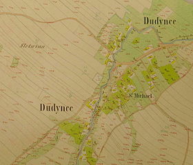
Polski: Dudyńce, gm. Bukowsko, mapa z roku 1852, z zaznaczonym kosciolem oraz cmentarzem, wyslal Marek Silarski English: village Dudynce, Bukowsko district near Sanok, cadastral map 1852, author Marek Silarski |
| Date | (original) |
| Source | |
| Author |
Licensing
[edit]
|
This work is in the public domain in its country of origin and other countries and areas where the copyright term is the author's life plus 70 years or fewer. | |
| This file has been identified as being free of known restrictions under copyright law, including all related and neighboring rights. | |
Original upload log
[edit]
The original description page was here. All following user names refer to pl.wikipedia.
- 2005-09-14 08:38 Mareksilarski 1477×1268× (350220 bytes) , Dudyńce, gm. Bukowsko, mapa z roku 1852, z zaznaczonym kosciolem oraz cmentarzem, wyslal Marek Silarski, village Dudynce, Bukowsko district near Sanok, cadastral map 1852, author Marek Silarski,
File history
Click on a date/time to view the file as it appeared at that time.
| Date/Time | Thumbnail | Dimensions | User | Comment | |
|---|---|---|---|---|---|
| current | 15:50, 25 March 2010 | | 1,477 × 1,268 (342 KB) | File Upload Bot (Magnus Manske) (talk | contribs) | {{BotMoveToCommons|pl.wikipedia|year={{subst:CURRENTYEAR}}|month={{subst:CURRENTMONTHNAME}}|day={{subst:CURRENTDAY}}}} {{Information |Description={{pl|Dudyńce, gm. Bukowsko, mapa z roku 1852, z zaznaczonym kosciolem oraz cmentarzem, wyslal Marek Silarsk |
You cannot overwrite this file.
File usage on Commons
There are no pages that use this file.
File usage on other wikis
The following other wikis use this file:
- Usage on de.wikipedia.org