File:Duchy of Naxos locator.svg
Jump to navigation
Jump to search

Size of this PNG preview of this SVG file: 730 × 600 pixels. Other resolutions: 292 × 240 pixels | 584 × 480 pixels | 935 × 768 pixels | 1,246 × 1,024 pixels | 2,492 × 2,048 pixels | 1,510 × 1,241 pixels.
Original file (SVG file, nominally 1,510 × 1,241 pixels, file size: 151 KB)
Captions
Captions
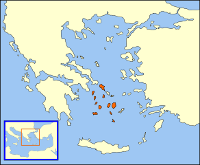
Locator map of the Duchy of Naxos, also known as the Duchy of the Archipelago
Summary
[edit]| Description |
A "locator" (text- and language-free) map of the Duchy of Naxos, also known as the Duchy of the Archipelago, dated approximately 1450, just before the fall of Constantinople. The English language parent map of this locator map: |
| Date | 12 April 2007 (original upload date) |
| Source | No machine-readable source provided. Own work assumed (based on copyright claims). |
| Author | No machine-readable author provided. MapMaster assumed (based on copyright claims). |

Licensing
[edit]
I, the copyright holder of this work, hereby publish it under the following licenses:

|
Permission is granted to copy, distribute and/or modify this document under the terms of the GNU Free Documentation License, Version 1.2 or any later version published by the Free Software Foundation; with no Invariant Sections, no Front-Cover Texts, and no Back-Cover Texts. A copy of the license is included in the section entitled GNU Free Documentation License. |
| This file is licensed under the Creative Commons Attribution-Share Alike 3.0 Unported license. | ||
| ||
| This licensing tag was added to this file as part of the GFDL licensing update. |
This file is licensed under the Creative Commons Attribution 2.5 Generic license.
- You are free:
- to share – to copy, distribute and transmit the work
- to remix – to adapt the work
- Under the following conditions:
- attribution – You must give appropriate credit, provide a link to the license, and indicate if changes were made. You may do so in any reasonable manner, but not in any way that suggests the licensor endorses you or your use.
You may select the license of your choice.
File history
Click on a date/time to view the file as it appeared at that time.
| Date/Time | Thumbnail | Dimensions | User | Comment | |
|---|---|---|---|---|---|
| current | 19:03, 1 August 2013 | | 1,510 × 1,241 (151 KB) | Phso2 (talk | contribs) | more accurate |
| 01:42, 16 April 2007 |  | 1,510 × 1,241 (166 KB) | MapMaster (talk | contribs) | Duchy of Naxos update | |
| 19:07, 12 April 2007 |  | 1,510 × 1,241 (127 KB) | MapMaster (talk | contribs) | Try this again | |
| 19:03, 12 April 2007 | 317 × 3 (126 KB) | MapMaster (talk | contribs) | A "locator" (text- and language-free) map of the Duchy of Naxos, also known as the Duchy of the Archipelago. |
You cannot overwrite this file.
File usage on Commons
The following 2 pages use this file:
File usage on other wikis
The following other wikis use this file:
- Usage on ar.wikipedia.org
- Usage on az.wikipedia.org
- Usage on be.wikipedia.org
- Usage on bg.wikipedia.org
- Usage on ca.wikipedia.org
- Usage on cs.wikipedia.org
- Usage on de.wikipedia.org
- Usage on el.wikipedia.org
- Usage on en.wikipedia.org
- Usage on eo.wikipedia.org
- Usage on es.wikipedia.org
- Usage on et.wikipedia.org
- Usage on fa.wikipedia.org
- Usage on fr.wikipedia.org
- Usage on gl.wikipedia.org
- Usage on hu.wikipedia.org
- Usage on id.wikipedia.org
- Usage on it.wikipedia.org
- Usage on ja.wikipedia.org
- Usage on la.wikipedia.org
- Usage on li.wikipedia.org
- Usage on nl.wikipedia.org
- Usage on oc.wikipedia.org
- Usage on pl.wikipedia.org
- Usage on pt.wikipedia.org
- Usage on ro.wikipedia.org
- Usage on ru.wikipedia.org
- Usage on sl.wikipedia.org
- Usage on sr.wikipedia.org
- Usage on sv.wikipedia.org
- Usage on tr.wikipedia.org
- Usage on vi.wikipedia.org
- Usage on www.wikidata.org