File:Dubai, UAE (ASTER).jpg
Jump to navigation
Jump to search

Size of this preview: 459 × 600 pixels. Other resolutions: 184 × 240 pixels | 367 × 480 pixels | 587 × 768 pixels | 783 × 1,024 pixels | 1,567 × 2,048 pixels | 2,723 × 3,559 pixels.
Original file (2,723 × 3,559 pixels, file size: 1.08 MB, MIME type: image/jpeg)
Captions
Captions
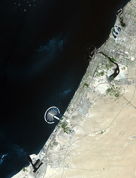
The city of Dubai is located in the northeastern part of the United Arab Emirates (UAE) along the Persian Gulf. Dubai is the capital city of the emirate of Dubai, one of seven emirates forming the United Arab Emirates.
Summary
[edit].jpg&action=edit§ion=1)
| Description |
English: The city of Dubai is located in the northeastern part of the United Arab Emirates (UAE) along the Persian Gulf. Dubai is the capital city of the emirate of Dubai, one of seven emirates forming the United Arab Emirates. Dubai is the second largest city next to Abu Dhabi in UAE. The upper part of the image shows the center of the city, which developed along the west side of the Dubai Creek. Dubai shows 2 different characters: one as a business district lined with high-rise buildings along the creek; and another as a resort with Jumeirah Beach and the safari tour of the desert, shown at the lower left of the image. Off the coast of Jumeirah Beach is the world's largest man-made island resort The Palm in the Persian Gulf, now under construction. The design of the palm tree-shaped island can be seen in the image. The image covers an area of 40.8 x 53.5 km, was acquired 17 September 2003, and is located at 25.2 degrees North latitude, 54.9 degrees East longitude. |
||
| Date | Taken on 17 September 2003 | ||
| Source |
|
||
| Author | NASA/METI/AIST/Japan Space Systems, and U.S./Japan ASTER Science Team |
| Object location | | View this and other nearby images on: OpenStreetMap |
|---|
.jpg¶ms=025.200000_N_0054.900000_E_globe:Earth_class:object_type:object__&language=en)
| This media is a product of the Terra mission Credit and attribution belongs to the Advanced Spaceborne Thermal Emission and Reflection Radiometer (ASTER) team, NASA/METI/AIST/Japan Space Systems |
Licensing
[edit].jpg&action=edit§ion=2)
| This file is in the public domain in the United States because it was solely created by NASA. NASA copyright policy states that "NASA material is not protected by copyright unless noted". (See Template:PD-USGov, NASA copyright policy page or JPL Image Use Policy.) | ||
 |
Warnings:
|
File history
Click on a date/time to view the file as it appeared at that time.
| Date/Time | Thumbnail | Dimensions | User | Comment | |
|---|---|---|---|---|---|
| current | 09:29, 24 June 2023 | | 2,723 × 3,559 (1.08 MB) | OptimusPrimeBot (talk | contribs) | #Spacemedia - Upload of https://asterweb.jpl.nasa.gov/gallery/images/dubai.jpg via Commons:Spacemedia |
You cannot overwrite this file.
File usage on Commons
There are no pages that use this file.
File usage on other wikis
The following other wikis use this file:
- Usage on en.wikipedia.org
.jpg&oldid=777002842)