File:Dry River Canyon Trail.jpg

Original file (3,300 × 2,550 pixels, file size: 1.44 MB, MIME type: image/jpeg)
Captions
Captions
Summary
[edit]
| Description |
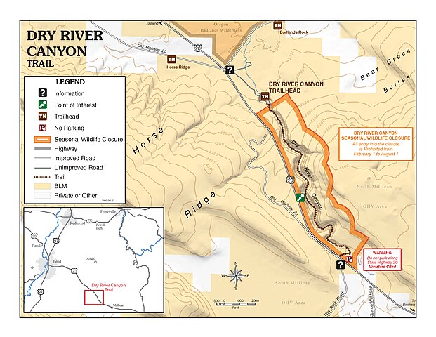
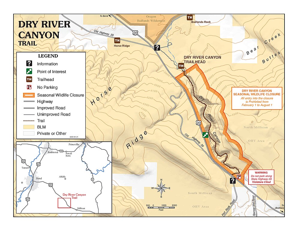
English: An ancient river cut the canyon in which now "flows" the Dry River. Once draining ancient Lake Millican, the Dry River's course can now be traced through the Oregon Badlands Wilderness north to the Crooked River. The drainage area of Dry River extends eastward to Hampton Butte and southward to the east flank of Newberry Volcano and all of Pine Mountain. During ice ages, Newberry Volcano hosted large glaciers. Runoff from these glaciers contributed to the flow of Dry River. Dry River Canyon, up to 300 feet deep, exposes layers of lava and cinders from ancient volcanoes of nearby Horse Ridge and Bear Creek Buttes.
A hike up the Dry River Canyon trail reveals hints of the energetic river which once flowed here. Rounded boulders, or grounded holes in bedrock caused by churning rock and water, and gravel at the bottom of the canyon show evidence of its watery past. Today, these tinajas hold water long after a rainfall and provide water for wildlife. Geological evidence is not the only clue to the canyon's past environment: several large Ponderosa pine trees linger on the canyon bottom, relics of a past ecosystem which prevailed during cooler times. The Trail Starting at an dispersed campsite at the canyon's mouth, the primitive and un-maintained Dry River Canyon trail follows the canyon bottom. At approximately 2.3 miles, the trail disappears into a large rockfall. For most people, this is a good turn-around point. Only experienced hikers who are comfortable rock-hopping should continue beyond this point. The trail resumes after about 50 yards and continues for another 0.75 miles to the head of the canyon where it emerges at State highway 20 opposite Evans Well Road. Please respect adjacent private property by staying on the trail. The total length of the trail is 3.2 miles. Annual Seasonal Closure Each year, Dry River Canyon is closed in its entirety to all uses from February 1 until August 31 to protect sensitive wildlife while they breed. Most years, however, the canyon re-opens much earlier, depending on when the young wildlife are ready to fend for themselves. Don't enter the canyon during the closure period violations of this closure are subject to heavy fines and/or imprisonment. For more information: 3050 N.E. 3rd Street Prineville, OR 97754 541-416-6700 |
| Date | |
| Source | https://www.flickr.com/photos/50169152@N06/30715549105/ |
| Author | BLM Oregon & Washington |
Licensing
[edit]
- You are free:
- to share – to copy, distribute and transmit the work
- to remix – to adapt the work
- Under the following conditions:
- attribution – You must give appropriate credit, provide a link to the license, and indicate if changes were made. You may do so in any reasonable manner, but not in any way that suggests the licensor endorses you or your use.
| This image was originally posted to Flickr by BLM Oregon & Washington at https://flickr.com/photos/50169152@N06/30715549105. It was reviewed on 7 March 2022 by FlickreviewR 2 and was confirmed to be licensed under the terms of the cc-by-2.0. |
File history
Click on a date/time to view the file as it appeared at that time.
| Date/Time | Thumbnail | Dimensions | User | Comment | |
|---|---|---|---|---|---|
| current | 20:37, 7 March 2022 | | 3,300 × 2,550 (1.44 MB) | Ser Amantio di Nicolao (talk | contribs) | Uploaded a work by BLM Oregon & Washington from https://www.flickr.com/photos/50169152@N06/30715549105/ with UploadWizard |
You cannot overwrite this file.
File usage on Commons
There are no pages that use this file.