File:Drought in France.jpg

Original file (3,535 × 2,567 pixels, file size: 5 MB, MIME type: image/jpeg)
Captions
Captions
Summary
[edit]
| Description |
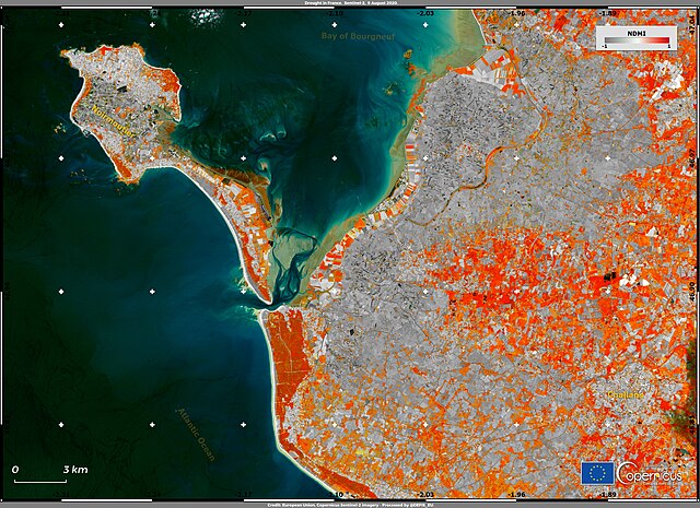
English: France, in addition to the extreme temperatures of early August 2020, is struggling with a severe drought. According to reports from the Ministry of Ecological Transition, on 1 September, 76 departments exceeded the surveillance threshold and implemented water restriction measures to cope with drought. There are severe damages to the agricultural sectors, moreover, two nuclear reactors have been shut down because the cooling process was difficult to manage due to the scarcity of water. This image shows the Normalised Difference Moisture Index (NDMI) derived from data acquired by one of the Copernicus Sentinel-2 satellites on 9 August 2020 for the Vendée department in the Pays de la Loire region, in western France. The NDMI provides values representative of the amount of water present in the soil and vegetation, and in this particular visualisation shows, in grey tones, the areas with severe water deficit. The Copernicus Emergency Management Service includes a European Drought Observatory which contains maps and report on ongoing drought episodes. In addition to the use of data derived from the satellites of the Copernicus Sentinel-2 mission, drought monitoring can be carried out with data obtained from the Copernicus Sentinel-1 mission. The RADAR data, independent of cloud cover, obtained by the Sentinel-1 mission are particularly suitable for describing dynamics between the dry and wet seasons. |
| Date | 3 September 2020 (upload date) |
| Source | Drought in France |
| Author | European Union , Copernicus Sentinel-2 imagery |
Licensing
[edit]

|
This image contains data from a satellite in the Copernicus Programme, such as Sentinel-1, Sentinel-2 or Sentinel-3. Attribution is required when using this image.
Attribution: Contains modified Copernicus Sentinel data 2020
The use of Copernicus Sentinel Data is regulated under EU law (Commission Delegated Regulation (EU) No 1159/2013 and Regulation (EU) No 377/2014). Relevant excerpts:
Free access shall be given to GMES dedicated data [...] made available through GMES dissemination platforms [...].
Access to GMES dedicated data [...] shall be given for the purpose of the following use in so far as it is lawful:
GMES dedicated data [...] may be used worldwide without limitations in time.
GMES dedicated data and GMES service information are provided to users without any express or implied warranty, including as regards quality and suitability for any purpose. |
File history
Click on a date/time to view the file as it appeared at that time.
| Date/Time | Thumbnail | Dimensions | User | Comment | |
|---|---|---|---|---|---|
| current | 09:56, 31 July 2023 | | 3,535 × 2,567 (5 MB) | OptimusPrimeBot (talk | contribs) | #Spacemedia - Upload of https://www.copernicus.eu/system/files/2020-09/image_day/DroughtFrance_credit_row.jpg via Commons:Spacemedia |
You cannot overwrite this file.
File usage on Commons
There are no pages that use this file.