File:Drax power station.jpg
Jump to navigation
Jump to search
No higher resolution available.
Drax_power_station.jpg (640 × 457 pixels, file size: 58 KB, MIME type: image/jpeg)
Captions
Captions
Add a one-line explanation of what this file represents
Summary
[edit]
| Description |
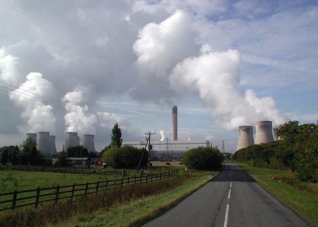
English: Carr Lane, Long Drax Looking west along Carr Lane from the site of the level crossing on the disused Hull & Barnsley Railway. Services on the Hull & Barnsley Railway line west of South Howden only lasted from the 1880s until 1st January 1932 and the regular service between Hull and South Howden ended on 30th July 1955, although some excursion traffic continued until about 1958. A short stretch of the line was reopened at Drax in the '70s to transport coal from nearby mines to the power station. Carr Lane is a common name in these parts, the carrs traditionally meaning rough pasture on reclaimed marshland which was only suitable for grazing when the water level was low. The lane here was widened in the early 1970s to accommodate the huge loads being transported from a jetty on the River Ouse during the building of the power station. Built between 1974 and 1986, Drax was the last coal-fired plant to be built in Britain and is also the largest, producing around 7% of the country's electricity. |
| Date | |
| Source | From geograph.org.uk |
| Author | Paul Glazzard |
| Camera location | | View this and other nearby images on: OpenStreetMap |
|---|
Licensing
[edit]

|
This image was taken from the Geograph project collection. See this photograph's page on the Geograph website for the photographer's contact details. The copyright on this image is owned by Paul Glazzard and is licensed for reuse under the Creative Commons Attribution-ShareAlike 2.0 license.
|
This file is licensed under the Creative Commons Attribution-Share Alike 2.0 Generic license.
Attribution: Paul Glazzard
- You are free:
- to share – to copy, distribute and transmit the work
- to remix – to adapt the work
- Under the following conditions:
- attribution – You must give appropriate credit, provide a link to the license, and indicate if changes were made. You may do so in any reasonable manner, but not in any way that suggests the licensor endorses you or your use.
- share alike – If you remix, transform, or build upon the material, you must distribute your contributions under the same or compatible license as the original.
File history
Click on a date/time to view the file as it appeared at that time.
| Date/Time | Thumbnail | Dimensions | User | Comment | |
|---|---|---|---|---|---|
| current | 20:36, 12 February 2009 | | 640 × 457 (58 KB) | Fintan264 (talk | contribs) | {{Information |Description=Drax Power Station |Source=http://www.geograph.org.uk/photo/581981 |Date=10 October 2007 |Author=Paul Glazzard |Permission= |other_versions= }} Category:Coal-fired power stations in England |
You cannot overwrite this file.
File usage on Commons
There are no pages that use this file.
File usage on other wikis
The following other wikis use this file:
- Usage on de.wikipedia.org
- Usage on hr.wikipedia.org