File:Draught of the Bay of Honduras and the Musqueto Shoar. LOC gm72003580.jpg
Jump to navigation
Jump to search

Size of this preview: 442 × 599 pixels. Other resolutions: 177 × 240 pixels | 354 × 480 pixels | 567 × 768 pixels | 756 × 1,024 pixels | 1,512 × 2,048 pixels | 9,284 × 12,576 pixels.
Original file (9,284 × 12,576 pixels, file size: 14.01 MB, MIME type: image/jpeg)
Captions
Captions
Add a one-line explanation of what this file represents
Summary
[edit]| Warning | The original file is very high-resolution. It might not load properly or could cause your browser to freeze when opened at full size. |
|---|
| Description |
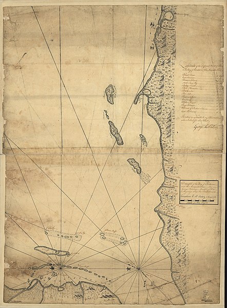
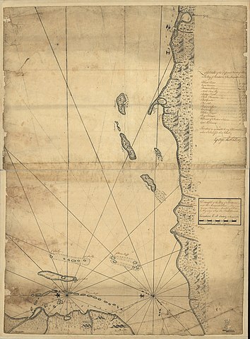
English: Scale ca. 1:430,000. Manuscript, pen-and-ink and watercolor. Has watermark. Oriented with north to the left. Relief shown pictorially. Depths shown by soundings. "Variation 6d. 30 m. easterly in the year 1764." LC Maps of North America, 1750-1789, 2127 LC Luso-Hispanic World, 61 Shows part of the coasts of Honduras and Belize. In pencil: 32. Includes table "Latitude of the different points of land in the Bay of Honduros & the Musqueto Shoar." Available also through the Library of Congress Web site as a raster image. Vault AACR2: 100; 650/1; 651/2 |
||
| Title | Draught of the Bay of Honduras and the Musqueto Shoar. | ||
| Shelf ID | G4802.H6P5 1764 .R6 | ||
| Date | |||
| Source | https://www.loc.gov/item/gm72003580/ | ||
| Author | Robertson, George; Prince Edward (Ship) | ||
| Permission (Reusing this file) |
|
||
| Other versions |
|
||
| Location | Gulf Of Honduras · Honduras · Honduras, Gulf Of. | ||
| Part of | Cultural Landscapes · Military Battles And Campaigns · Catalog · American Memory · Geography And Map Division · American Revolution And Its Era: Maps And Charts Of North America And The West Indies, 1750-1789 | ||
| Subject | Honduras, Gulf Of · Maps, Manuscript · Early Works To 1800 · Honduras · Nautical Charts |


Licensing
[edit]
|
This is a faithful photographic reproduction of a two-dimensional, public domain work of art. The work of art itself is in the public domain for the following reason:
The official position taken by the Wikimedia Foundation is that "faithful reproductions of two-dimensional public domain works of art are public domain".
This photographic reproduction is therefore also considered to be in the public domain in the United States. In other jurisdictions, re-use of this content may be restricted; see Reuse of PD-Art photographs for details. | ||||
File history
Click on a date/time to view the file as it appeared at that time.
| Date/Time | Thumbnail | Dimensions | User | Comment | |
|---|---|---|---|---|---|
| current | 04:31, 23 May 2018 | | 9,284 × 12,576 (14.01 MB) | Fæ (talk | contribs) | LOC Maps https://www.loc.gov/item/gm72003580/ #13563 |
You cannot overwrite this file.
File usage on Commons
The following page uses this file: