File:Dramatic Eruption on Iceland's Reykjanes Peninsula (MODIS 2024-05-31).jpg
Original file (1,267 × 1,018 pixels, file size: 289 KB, MIME type: image/jpeg)
Captions
Captions
Summary
[edit].jpg&action=edit§ion=1)
| Description |
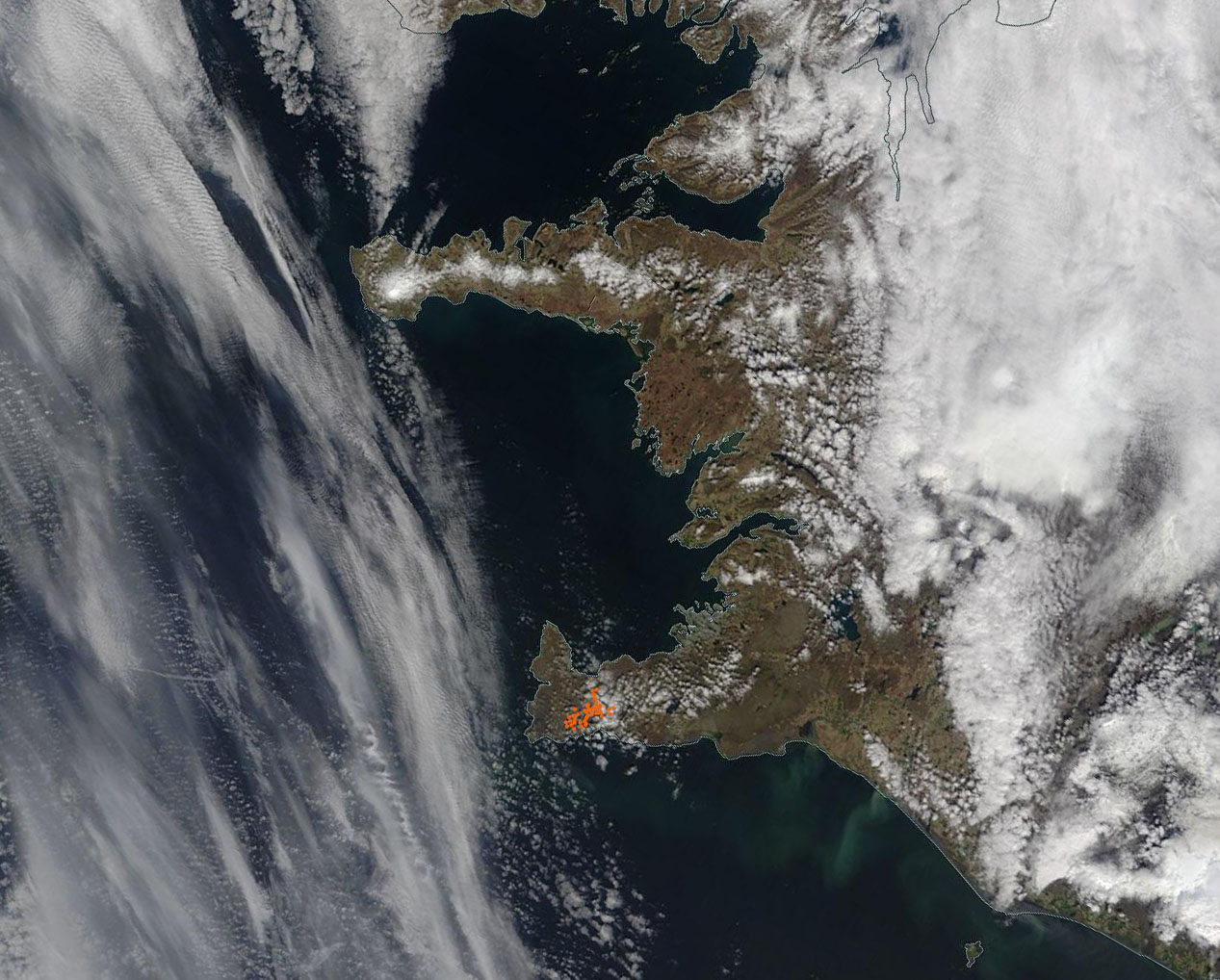
English: A dramatic eruption of a volcano near the town of Grindavik, Iceland, sent nearby populations scrambling for safety on May 29, 2024. A swarm of earthquakes and tremors early that morning caused evacuation of workers at the Svartsengi power plant, all but three residents of Grindavik, and visitors and residents of the Blue Lagoon Spa area, according to a report from the Global Volcanism Program of the Smithsonian Institution and US Geological Survey Global Volcanism.
The Iceland Meteorological Office (IMO) reported that at least two fissures opened. The copious lava flow was estimated moving at 1,500-2,000 cubic meters per second (53,000-71,000 cubic feet/second). Some of the explosive activity began when magma came into contact with groundwater, causing water to quickly be converted to steam, causing steam explosions and widespread ash (tephra) fall. Lava fountains were estimated to leap up to 50 meters (164 feet) upwards from the fissures. By that afternoon, the main part of the eruptive fissure was estimated at about 2.4 kilometers (1.5 miles) in length. Models estimated that about 14 million cubic meters (494 million cubic feet) of magma had flowed Svartsengi into the Sundhnuks craters series, with magma flow continuing. Lava had flowed over the Grindavik Road and Nesvegur Road. Barriers that protect the town of Grindavik have held, and so far no people have been reported to have been injured. Explosive activity had waned by May 30, with some lava flow and substantial steam continuing. This is the fifth eruption in the same area of the Reykjanes Peninsula since December 2024, and it has been called the most explosive and the largest. The Moderate Resolution Imaging Spectroradiometer (MODIS) on NASA’s Terra satellite acquired a true-color image of the Reykjanes Peninsula on May 29. Red marks areas where the thermal bands on the MODIS instrument detected high temperatures. In this case, these “hot spots” mark the location of rapidly expanding lava flows. |
||
| Date | Taken on 29 May 2024 | ||
| Source |
Dramatic Eruption on Iceland's Reykjanes Peninsula (direct link)
|
||
| Author | MODIS Land Rapid Response Team, NASA GSFC |
| This media is a product of the Terra mission Credit and attribution belongs to the mission team, if not already specified in the "author" row |
Licensing
[edit].jpg&action=edit§ion=2)
| This file is in the public domain in the United States because it was solely created by NASA. NASA copyright policy states that "NASA material is not protected by copyright unless noted". (See Template:PD-USGov, NASA copyright policy page or JPL Image Use Policy.) | ||
 |
Warnings:
|
File history
Click on a date/time to view the file as it appeared at that time.
| Date/Time | Thumbnail | Dimensions | User | Comment | |
|---|---|---|---|---|---|
| current | 05:05, 31 May 2024 | | 1,267 × 1,018 (289 KB) | OptimusPrimeBot (talk | contribs) | #Spacemedia - Upload of http://modis.gsfc.nasa.gov/gallery/images/image05312024_250m.jpg via Commons:Spacemedia |
You cannot overwrite this file.
File usage on Commons
There are no pages that use this file.
.jpg&oldid=909380528)