File:Drag your cursor or use the controls at the bottom of the image to navigate this 360-degree photo. What clues help you identify (024544a7-6750-4ce0-b626-d9b33c932325).JPG
Jump to navigation
Jump to search

Size of this preview: 800 × 400 pixels. Other resolutions: 320 × 160 pixels | 640 × 320 pixels | 1,024 × 512 pixels | 1,280 × 640 pixels | 2,560 × 1,280 pixels | 5,376 × 2,688 pixels.
Original file (5,376 × 2,688 pixels, file size: 3.93 MB, MIME type: image/jpeg)
Captions
Captions
Add a one-line explanation of what this file represents
| Camera location | | View this and other nearby images on: OpenStreetMap |
|---|
.JPG¶ms=032.994167_N_-111.537500_E_globe:Earth_type:camera_alt:432_source:exif_&language=en)

|
This media file is uncategorized.
Please help improve this media file by adding it to one or more categories, so it may be associated with related media files (how?), and so that it can be more easily found.
Please notify the uploader with {{subst:Please link images|File:Drag your cursor or use the controls at the bottom of the image to navigate this 360-degree photo. What clues help you identify (024544a7-6750-4ce0-b626-d9b33c932325).JPG}} ~~~~ |
Summary
[edit].JPG&action=edit§ion=1)
| English: Challenge 2 | ||||
|---|---|---|---|---|
| Photographer |
English: NPS Photo |
|||
| Title |
English: Challenge 2 |
|||
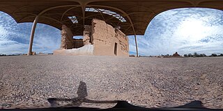
| Description |
English: Spherical image of the ruins of a two-story Adobe structure, which has a door and a collapsed corner. There is a prominent metal overhang covering the runs. Drag your cursor or use the controls at the bottom of the image to navigate this 360-degree photo. What clues help you identify this park? |
|||
| Depicted place |
English: Latitude: 32.9941666666667, Longitude: -111.5375, Elevation: 432 |
|||
| Date | Taken on 20 May 2019 | |||
| Accession number | ||||
| Source |
English: NPGallery |
|||
| Permission (Reusing this file) |
|
|||
| NPS Unit Code | OOC | |||
File history
Click on a date/time to view the file as it appeared at that time.
| Date/Time | Thumbnail | Dimensions | User | Comment | |
|---|---|---|---|---|---|
| current | 04:48, 13 January 2022 | | 5,376 × 2,688 (3.93 MB) | BMacZeroBot (talk | contribs) | Batch upload (Commons:Batch uploading/NPGallery) |
You cannot overwrite this file.
File usage on Commons
The following page uses this file:
.JPG)
.JPG&oldid=752068848)