File:Dortmund-Ems-Kanal.svg
Jump to navigation
Jump to search

Size of this PNG preview of this SVG file: 195 × 598 pixels. Other resolutions: 78 × 240 pixels | 156 × 480 pixels | 250 × 768 pixels | 333 × 1,024 pixels | 667 × 2,048 pixels | 318 × 976 pixels.
Original file (SVG file, nominally 318 × 976 pixels, file size: 120 KB)
Captions
Captions
Add a one-line explanation of what this file represents
Summary
[edit]
| Description |
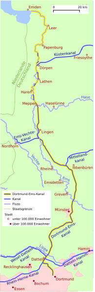
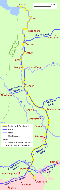
Deutsch: Übersichtskarte des Dortmund-Ems-Kanals |
| Date | |
| Source | Own work, based on Open Street Map |
| Author | Tentotwo |
Licensing
[edit]
I, the copyright holder of this work, hereby publish it under the following license:
This file is licensed under the Creative Commons Attribution-Share Alike 3.0 Unported license.
- You are free:
- to share – to copy, distribute and transmit the work
- to remix – to adapt the work
- Under the following conditions:
- attribution – You must give appropriate credit, provide a link to the license, and indicate if changes were made. You may do so in any reasonable manner, but not in any way that suggests the licensor endorses you or your use.
- share alike – If you remix, transform, or build upon the material, you must distribute your contributions under the same or compatible license as the original.

|
This map has been made or improved in the German Kartenwerkstatt (Map Lab). You can propose maps to improve as well.
|
File history
Click on a date/time to view the file as it appeared at that time.
| Date/Time | Thumbnail | Dimensions | User | Comment | |
|---|---|---|---|---|---|
| current | 11:19, 2 September 2013 | 318 × 976 (120 KB) | Debenben (talk | contribs) | Fluss gehört auch zum Kanal, Schrift einheitlich | |
| 03:42, 12 December 2011 | 318 × 976 (121 KB) | Tentotwo (talk | contribs) | Legendentext korrigiert | ||
| 03:25, 12 December 2011 | 318 × 976 (121 KB) | Tentotwo (talk | contribs) | Platzierung einiger Beschriftungen angepasst, um fehlerhaftem Rendering Rechnung zu tragen | ||
| 03:23, 12 December 2011 | 318 × 976 (121 KB) | Tentotwo (talk | contribs) | Platzierung einiger Beschriftungen angepasst, um fehlerhaftem Rendering Rechnung zu tragen | ||
| 03:19, 12 December 2011 | 318 × 976 (121 KB) | Tentotwo (talk | contribs) | Kerning und Kurven fuer Schriftpfade entfernt | ||
| 03:09, 12 December 2011 | 318 × 976 (122 KB) | Tentotwo (talk | contribs) | Bebauungsflaechen korrigiert, Staedte hinzugefuegt, Datteln-Hamm-Kanal korrigiert | ||
| 11:40, 11 December 2011 | 318 × 975 (141 KB) | Tentotwo (talk | contribs) |
You cannot overwrite this file.
File usage on Commons
The following page uses this file:
File usage on other wikis
The following other wikis use this file:
- Usage on ca.wikipedia.org
- Usage on da.wikipedia.org
- Usage on de.wikipedia.org
- Usage on de.wikivoyage.org
- Usage on en.wikipedia.org
- Usage on eo.wikipedia.org
- Usage on fr.wikipedia.org
- Usage on fy.wikipedia.org
- Usage on ja.wikipedia.org
- Usage on nl.wikipedia.org
- Usage on uk.wikipedia.org
- Usage on www.wikidata.org