File:Dora1-Map(WithDora2).jpg
Jump to navigation
Jump to search
Size of this preview: 595 × 599 pixels. Other resolutions: 238 × 240 pixels | 477 × 480 pixels | 693 × 698 pixels.
Original file (693 × 698 pixels, file size: 65 KB, MIME type: image/jpeg)
Captions
Captions
Add a one-line explanation of what this file represents
Summary
[edit].jpg&action=edit§ion=1)
| Description |
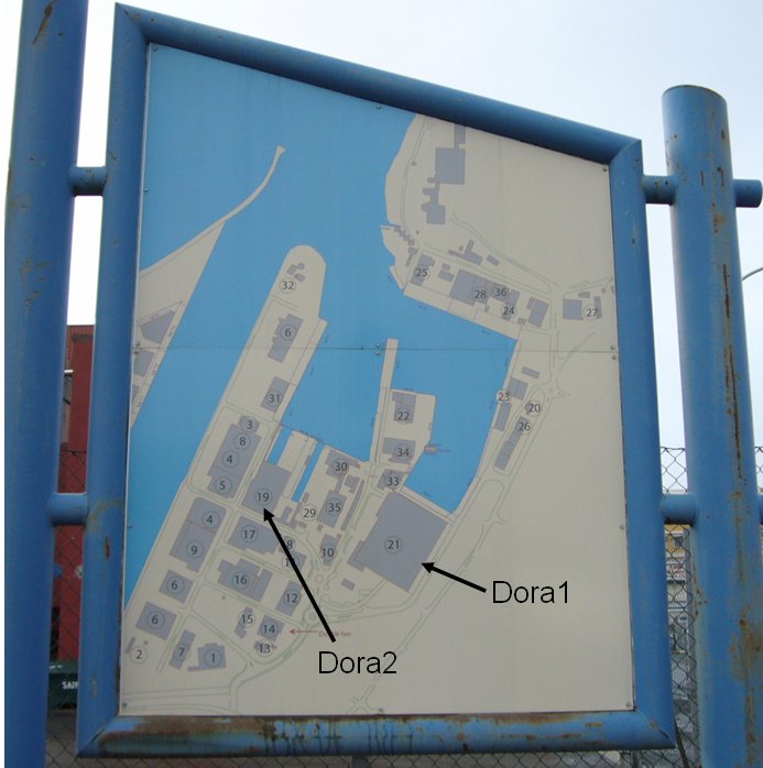
Français : Panneau d'information montrant les bâtiments portuaires du fjord avec des flèches supplémentaires pour pointer les complexes de Dora. |
| Date | |
| Source | Own work by the original uploader |
| Author | dswojo |
Licensing
[edit].jpg&action=edit§ion=2)
| This work has been released into the public domain by its author, Dswojo at English Wikipedia. This applies worldwide. In some countries this may not be legally possible; if so: Dswojo grants anyone the right to use this work for any purpose, without any conditions, unless such conditions are required by law. |
Original upload log
[edit].jpg&action=edit§ion=3)
The original description page was here. All following user names refer to en.wikipedia.
- 2007-04-20 17:47 Dswojo 693×698× (67040 bytes) photographer: dswojo April 2007
File history
Click on a date/time to view the file as it appeared at that time.
| Date/Time | Thumbnail | Dimensions | User | Comment | |
|---|---|---|---|---|---|
| current | 06:00, 19 February 2014 | | 693 × 698 (65 KB) | Plbcr (talk | contribs) | User created page with UploadWizard |
You cannot overwrite this file.
File usage on Commons
There are no pages that use this file.
File usage on other wikis
The following other wikis use this file:
- Usage on ar.wikipedia.org
- Usage on de.wikipedia.org
- Usage on en.wikipedia.org
- Usage on fr.wikipedia.org
- Usage on ru.wikipedia.org
.jpg&oldid=488289311)