File:Dongtingriversmap.png
Jump to navigation
Jump to search

Size of this preview: 690 × 599 pixels. Other resolutions: 276 × 240 pixels | 553 × 480 pixels | 885 × 768 pixels | 1,200 × 1,042 pixels.
Original file (1,200 × 1,042 pixels, file size: 488 KB, MIME type: image/png)
Captions
Captions
Add a one-line explanation of what this file represents

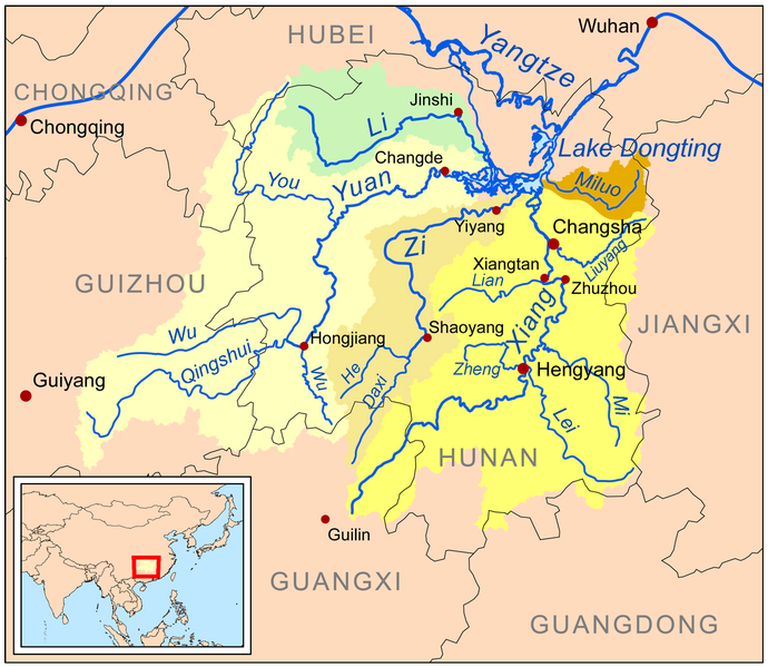
| Description | This is a map of the major rivers flowing into Lake Dongting; the Xiang, Zi, Yuan, Li and Miluo rivers. |
| Date | |
| Source | Own work using Digital Chart of the World and GTOPO data. |
| Author | Kmusser |
I, the copyright holder of this work, hereby publish it under the following license:
This file is licensed under the Creative Commons Attribution-Share Alike 3.0 Unported license.
- You are free:
- to share – to copy, distribute and transmit the work
- to remix – to adapt the work
- Under the following conditions:
- attribution – You must give appropriate credit, provide a link to the license, and indicate if changes were made. You may do so in any reasonable manner, but not in any way that suggests the licensor endorses you or your use.
- share alike – If you remix, transform, or build upon the material, you must distribute your contributions under the same or compatible license as the original.
File history
Click on a date/time to view the file as it appeared at that time.
| Date/Time | Thumbnail | Dimensions | User | Comment | |
|---|---|---|---|---|---|
| current | 14:34, 4 January 2024 | | 1,200 × 1,042 (488 KB) | Kmusser (talk | contribs) | Xiao Liuyang label fix |
| 00:06, 13 March 2009 |  | 1,200 × 1,042 (610 KB) | Kmusser (talk | contribs) | spelling fix | |
| 21:07, 12 March 2009 |  | 1,200 × 1,042 (611 KB) | Kmusser (talk | contribs) | {{Information |Description=This is a map of the major rivers flowing into Lake Dongting; the Xiang, Zi, Yuan, Li and Miluo rivers. |So |
You cannot overwrite this file.
File usage on Commons
The following 5 pages use this file:
File usage on other wikis
The following other wikis use this file:
- Usage on af.wikipedia.org
- Usage on arz.wikipedia.org
- Usage on ast.wikipedia.org
- Usage on bg.wikipedia.org
- Usage on bn.wikipedia.org
- Usage on bo.wikipedia.org
- Usage on bs.wikipedia.org
- Usage on ceb.wikipedia.org
- Usage on cs.wikipedia.org
- Usage on cy.wikipedia.org
- Usage on da.wikipedia.org
- Usage on de.wikipedia.org
- Usage on en.wikipedia.org
- Usage on eo.wikipedia.org
- Usage on es.wikipedia.org
- Usage on eu.wikipedia.org
View more global usage of this file.