File:Doetinchem-topografie.jpg

Original file (1,466 × 1,499 pixels, file size: 1.51 MB, MIME type: image/jpeg)
Captions
Captions
Summary
[edit]| DescriptionDoetinchem-topografie.jpg |
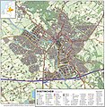
Nederlands: Topografisch beeld van de stad Doetinchem.
Op basis van de GML open geodata van de BRT/Top10NL (basisregistratie Topografie, Kadaster 2012), vrijgegeven door Kadaster op 30-11-2012 onder de Creative Commons BY licentie. Gebouwvlakken vanuit Open Geodata BAG extract (december 2012). Samenstelling en kleurenschema: Jan-Willem van Aalst, met QuantumGIS en Photoshop. |
| Date | |
| Source | Own work |
| Author | Janwillemvanaalst |
| Camera location | 51° 57′ 47.4″ N, 6° 17′ 13.78″ E | View this and other nearby images on: OpenStreetMap |
|---|
Licensing
[edit]- You are free:
- to share – to copy, distribute and transmit the work
- to remix – to adapt the work
- Under the following conditions:
- attribution – You must give appropriate credit, provide a link to the license, and indicate if changes were made. You may do so in any reasonable manner, but not in any way that suggests the licensor endorses you or your use.
- share alike – If you remix, transform, or build upon the material, you must distribute your contributions under the same or compatible license as the original.
File history
Click on a date/time to view the file as it appeared at that time.
| Date/Time | Thumbnail | Dimensions | User | Comment | |
|---|---|---|---|---|---|
| current | 18:48, 18 January 2013 |  | 1,466 × 1,499 (1.51 MB) | Janwillemvanaalst (talk | contribs) | Added various topographic improvements, which were already available in the BRT open-geodata source files: - Symbols for special physical appearances of land types such as "swampy terrain" - Symbol for carpool parking + large open parking spaces (in ad... |
| 11:19, 30 December 2012 |  | 1,466 × 1,499 (1.4 MB) | Janwillemvanaalst (talk | contribs) | Map redrawn using updated (Dec. 2012) open geodata Dutch government base registries BRT + BAG. Rendered using QuantumGIS and Photoshop. | |
| 05:23, 14 March 2012 |  | 2,633 × 2,223 (2.22 MB) | Janwillemvanaalst (talk | contribs) | Building polygons now taken from Open Geodata BAG registry (Jan. 2012); increased image resolution. | |
| 19:25, 11 February 2012 |  | 1,865 × 1,525 (1.51 MB) | Janwillemvanaalst (talk | contribs) |
You cannot overwrite this file.
File usage on Commons
There are no pages that use this file.
Metadata
This file contains additional information such as Exif metadata which may have been added by the digital camera, scanner, or software program used to create or digitize it. If the file has been modified from its original state, some details such as the timestamp may not fully reflect those of the original file. The timestamp is only as accurate as the clock in the camera, and it may be completely wrong.
| Orientation | Normal |
|---|---|
| Horizontal resolution | 72 dpi |
| Vertical resolution | 72 dpi |
| Software used | Adobe Photoshop Elements 11.0 Windows |
| File change date and time | 19:37, 18 January 2013 |
| Color space | sRGB |
| Date metadata was last modified | 20:37, 18 January 2013 |
| Date and time of digitizing | 17:20, 23 December 2012 |
| Unique ID of original document | xmp.did:4ED53A079E61E2118732BB0426125B02 |
