File:Disused terminal platforms of the former Southwold Railway at Halesworth, 1940 (geograph 5160102).jpg
Jump to navigation
Jump to search

Size of this preview: 800 × 461 pixels. Other resolutions: 320 × 184 pixels | 640 × 369 pixels | 1,024 × 590 pixels | 1,280 × 737 pixels | 2,349 × 1,353 pixels.
Original file (2,349 × 1,353 pixels, file size: 1.83 MB, MIME type: image/jpeg)
Captions
Captions
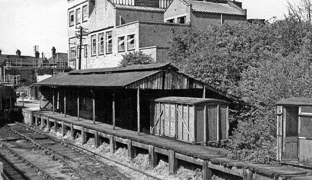
This is the goods transfer platform between the GE on the left and Southwold Railway on the right.
Summary
[edit].jpg&action=edit§ion=1)
| Description |
English: Disused terminal platforms of the former Southwold Railway at Halesworth, 1940 Adjoining the ex-GER station on the East Suffolk Railway, this was the Halesworth terminus of the 3 ft. gauge railway from Southwold, closed since 11/4/29 and now (2016) in process of restoration by the Southwold Railway Trust. |
| Date | Taken on 7 May 19401940-05-07 |
| Source | From geograph.org.uk |
| Author | Walter Dendy, deceased |
| Permission (Reusing this file) |
Creative Commons Attribution Share-alike license 2.0 |
| Attribution (required by the license) | Walter Dendy, deceased / Disused terminal platforms of the former Southwold Railway at Halesworth, 1940 / |
| Camera location | | View this and other nearby images on: OpenStreetMap |
|---|
.jpg¶ms=052.345403_N_0001.508375_E_globe:Earth_type:camera_heading:0.00_source:geograph&language=en)
| Object location | | View this and other nearby images on: OpenStreetMap |
|---|
.jpg¶ms=052.345450_N_0001.508500_E_globe:Earth_class:object_type:object_source:geograph-osgb36(TM39067772)_region:GB-GBN_heading:0.00&language=en)
Licensing
[edit].jpg&action=edit§ion=2)

|
This image was taken from the Geograph project collection. See this photograph's page on the Geograph website for the photographer's contact details. The copyright on this image is owned by Walter Dendy, deceased and is licensed for reuse under the Creative Commons Attribution-ShareAlike 2.0 license.
|
This file is licensed under the Creative Commons Attribution-Share Alike 2.0 Generic license.
Attribution: Walter Dendy, deceased
- You are free:
- to share – to copy, distribute and transmit the work
- to remix – to adapt the work
- Under the following conditions:
- attribution – You must give appropriate credit, provide a link to the license, and indicate if changes were made. You may do so in any reasonable manner, but not in any way that suggests the licensor endorses you or your use.
- share alike – If you remix, transform, or build upon the material, you must distribute your contributions under the same or compatible license as the original.
File history
Click on a date/time to view the file as it appeared at that time.
| Date/Time | Thumbnail | Dimensions | User | Comment | |
|---|---|---|---|---|---|
| current | 19:25, 9 November 2016 | | 2,349 × 1,353 (1.83 MB) | Efficacy (talk | contribs) | Transferred from geograph.co.uk using [https://tools.wmflabs.org/geograph2commons/ geograph2commons] |
You cannot overwrite this file.
File usage on Commons
The following page uses this file:
File usage on other wikis
The following other wikis use this file:
- Usage on en.wikipedia.org
.jpg&oldid=801615637)