File:Distribution of German Forces, 15-9-18.jpg
Jump to navigation
Jump to search

Size of this preview: 525 × 599 pixels. Other resolutions: 210 × 240 pixels | 421 × 480 pixels | 673 × 768 pixels | 898 × 1,024 pixels | 1,795 × 2,048 pixels | 12,176 × 13,889 pixels.
Original file (12,176 × 13,889 pixels, file size: 31.83 MB, MIME type: image/jpeg)
Captions
Captions
Add a one-line explanation of what this file represents
| Warning | The original file is very high-resolution. It might not load properly or could cause your browser to freeze when opened at full size. |
|---|
| Title |
English: Distribution of German Forces, 15-9-18 |
||||||||||||||||||||
| Description |
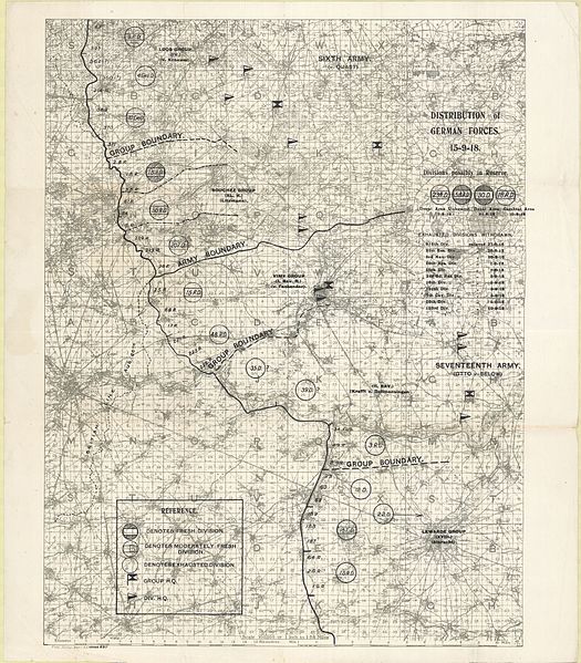
English: Sheet number: parts of sheets 36 and 57. First Army Front, German order of battle, September 1918. Title in black overprint. "[1st] Field Survey Battn. R.E. 6788 [numbers crossed out with black overprint and followed with] 6911". Shows "British Line Aug. 20th" in black overprint. Grey gridded base map (enlarge 1:40,000). Shows German armies (6th and 17th), group (Corps) and divisions, army and group boundaries. Scale of miles and kilometres at foot of base map. |
||||||||||||||||||||
| Date | |||||||||||||||||||||
| Source | McMaster University Research Collections; Fonds: WW1 Trench Maps: France; Box number: PC20; envelope_number: 633. | ||||||||||||||||||||
| Creator |
Field Service Battalion, Royal Engineers |
||||||||||||||||||||
| Permission (Reusing this file) |
|
||||||||||||||||||||
| Geotemporal data | |||||||||||||||||||||
| Map location | Roubaix, Haubourdin, Douai, Arras | ||||||||||||||||||||
| Map type | trench map | ||||||||||||||||||||
| Scale | 1:100,000 | ||||||||||||||||||||
| Heading |
 |
||||||||||||||||||||
| Bounding box |
|
||||||||||||||||||||
| Georeferencing | |||||||||||||||||||||
| Bibliographic data | |||||||||||||||||||||
| Map sheet | 36 and 57 | ||||||||||||||||||||
| Language | English | ||||||||||||||||||||
| Publisher |
Royal Engineers |
||||||||||||||||||||
| Archival data | |||||||||||||||||||||
| Collection |
|
||||||||||||||||||||
| Accession number |
PC0782 |
||||||||||||||||||||
| Dimensions | height: 58 cm (22.8 in); width: 51 cm (20 in) | ||||||||||||||||||||


File history
Click on a date/time to view the file as it appeared at that time.
| Date/Time | Thumbnail | Dimensions | User | Comment | |
|---|---|---|---|---|---|
| current | 14:03, 25 March 2016 | | 12,176 × 13,889 (31.83 MB) | Labattblueboy (talk | contribs) | {{Information |Description= Series Number Id: UNKNOWN. Sheet number: parts of sheets 36 and 57. First Army Front, German order of battle, September 1918. Title in black overprint. "[1st] Field Survey Battn. R.E. 6788 [numbers crossed out with black ove... |
You cannot overwrite this file.
File usage on Commons
The following page uses this file: