File:Distancia chinadega managua.png
Jump to navigation
Jump to search
No higher resolution available.
Distancia_chinadega_managua.png (690 × 576 pixels, file size: 100 KB, MIME type: image/png)
Captions
Captions
Add a one-line explanation of what this file represents
Summary
[edit]
| Description |
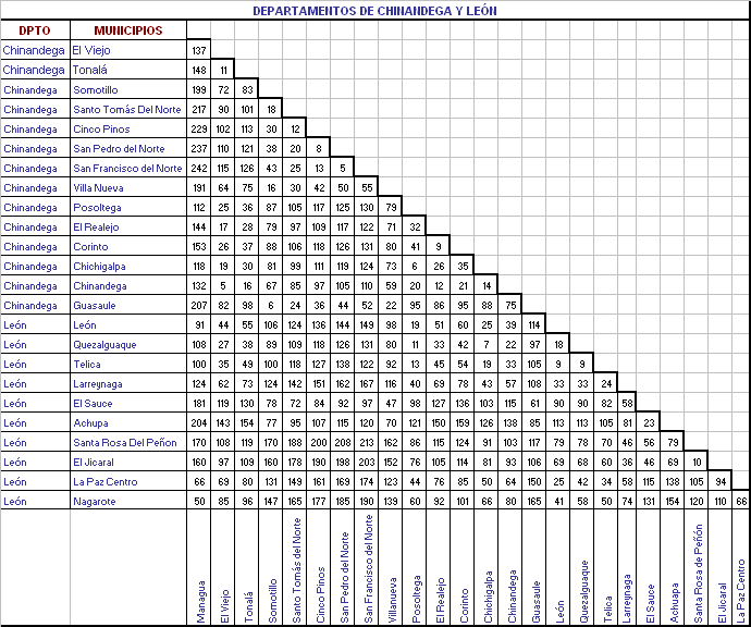
Español: Fue tomada de las bases de dato del INIFON de Nicragua. |
| Source | Own work |
| Author | SORIANONEARTH |
Imagen para mostras las diastancia del la zona de occidente.
Licensing
[edit]
I, the copyright holder of this work, hereby publish it under the following license:
This file is licensed under the Creative Commons Attribution 3.0 Unported license.
- You are free:
- to share – to copy, distribute and transmit the work
- to remix – to adapt the work
- Under the following conditions:
- attribution – You must give appropriate credit, provide a link to the license, and indicate if changes were made. You may do so in any reasonable manner, but not in any way that suggests the licensor endorses you or your use.
| Annotations | This image is annotated: View the annotations at Commons |
File history
Click on a date/time to view the file as it appeared at that time.
| Date/Time | Thumbnail | Dimensions | User | Comment | |
|---|---|---|---|---|---|
| current | 01:27, 29 October 2010 | | 690 × 576 (100 KB) | SORIANONEARTH (talk | contribs) | {{Information |Description={{es|1=Fue tomada de las bases de dato del INIFON de Nicragua.}} |Source={{own}} |Author=SORIANONEARTH |Date= |Permission= |other_versions= }} Imagen para mostras las diastancia del la zona de occidente. |
You cannot overwrite this file.
File usage on Commons
There are no pages that use this file.