File:Dispersant Aircraft (52129578139).jpg

Original file (4,032 × 1,831 pixels, file size: 3.64 MB, MIME type: image/jpeg)
Captions
Captions
Summary
[edit].jpg&action=edit§ion=1)
| Description |
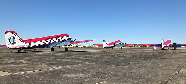
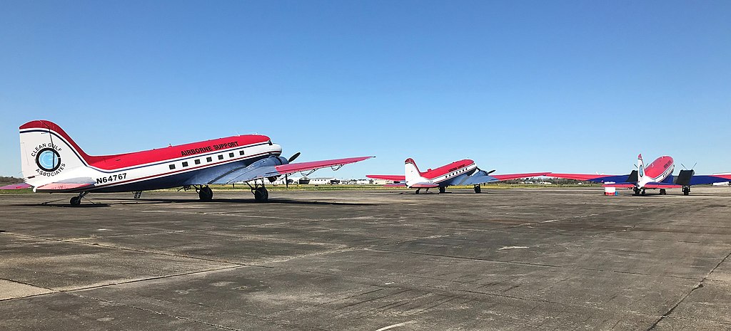
February 13, 2019 Presquille, LA Dispersant application and monitoring aircraft stand ready at an airfield. The fleet of aircraft are deployed by an oil spill removal organization (OSRO) to apply dispersants to an oil spill when directed. The aircraft have different functions - some spray the dispersants while others serve as spotters to monitor the effectiveness of the application. The use of dispersants is a response tactic that helps to mitigate the impact of a spill. When dispersants are applied to a slick, they break up the oil into lots of small droplets. These tiny droplets have a high surface area-to-volume ratio, making them easier for oil-eating microbes to break them down (through the process of biodegradation). Dispersant application strategies are listed in the Oil Spill Response Plans maintained by offshore facility owners and operators. BSEE Preparedness Analysts from the Oil Spill Preparedness Division (OSPD) regularly inspect these plans and dispersant stockpiles and application equipment to ensure compliance with regulations and to monitor the overall vigor of the oil spill preparedness and response community. Photo by: BSEE |
||||||||||
| Date | |||||||||||
| Source | Dispersant Aircraft | ||||||||||
| Author |
|
||||||||||
| Camera location | | View this and other nearby images on: OpenStreetMap |
|---|
.jpg¶ms=029.568655_N_-090.657242_E_globe:Earth_type:camera_source:Flickr_&language=en)
Licensing
[edit].jpg&action=edit§ion=2)
| This image was originally posted to Flickr by bseegov at https://flickr.com/photos/123443813@N05/52129578139. It was reviewed on 5 December 2023 by FlickreviewR 2 and was confirmed to be licensed under the terms of the Public Domain Mark. |
| This image or media file contains material based on a work of a United States Department of the Interior employee, created as part of that person's official duties. As a work of the U.S. federal government, such work is in the public domain in the United States. See the Department of the Interior copyright policy for more information. |  |
File history
Click on a date/time to view the file as it appeared at that time.
| Date/Time | Thumbnail | Dimensions | User | Comment | |
|---|---|---|---|---|---|
| current | 13:30, 2 August 2022 | | 4,032 × 1,831 (3.64 MB) | Geo Swan (talk | contribs) | Transferred from Flickr via #flickr2commons |
You cannot overwrite this file.
File usage on Commons
There are no pages that use this file.
.jpg&oldid=828090172)