File:Dijon-Prenois.png
Jump to navigation
Jump to search

Size of this preview: 800 × 373 pixels. Other resolutions: 320 × 149 pixels | 640 × 298 pixels | 1,383 × 644 pixels.
Original file (1,383 × 644 pixels, file size: 156 KB, MIME type: image/png)
Captions
Captions
Add a one-line explanation of what this file represents
Summary
[edit]
| Description |
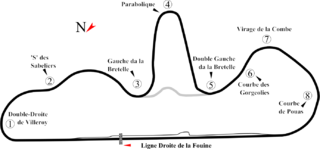
English: Track map for Dijon-Prenois. This PNG version is intended for browsers that don't support SVG. |
| Date | |
| Source | Own work |
| Author | Will Pittenger |

|
File:Dijon-Prenois Circuit.svg is a vector version of this file. It should be used in place of this PNG file when not inferior.
File:Dijon-Prenois.png → File:Dijon-Prenois Circuit.svg
For more information, see Help:SVG. |
 |
| Camera location | | View this and other nearby images on: OpenStreetMap |
|---|
Licensing
[edit]
| I, the copyright holder of this work, release this work into the public domain. This applies worldwide. In some countries this may not be legally possible; if so: I grant anyone the right to use this work for any purpose, without any conditions, unless such conditions are required by law. |
File history
Click on a date/time to view the file as it appeared at that time.
| Date/Time | Thumbnail | Dimensions | User | Comment | |
|---|---|---|---|---|---|
| current | 04:47, 16 July 2008 | | 1,383 × 644 (156 KB) | Will Pittenger (talk | contribs) | {{Information |Description={{en|1=Track map for w:Dijon-Prenois. This PNG version is intended for browsers that don't support SVG.}} |Source=Own work by uploader |Author=Will Pittenger |Date=7-15-2008 |Permission= |other_vers |
You cannot overwrite this file.
File usage on Commons
There are no pages that use this file.