File:Dietwiller, Mairie.jpg
Jump to navigation
Jump to search

Size of this preview: 749 × 600 pixels. Other resolutions: 300 × 240 pixels | 599 × 480 pixels | 959 × 768 pixels | 1,278 × 1,024 pixels | 2,557 × 2,048 pixels | 3,830 × 3,068 pixels.
Original file (3,830 × 3,068 pixels, file size: 2 MB, MIME type: image/jpeg)
Captions
Captions
Add a one-line explanation of what this file represents
| Description |
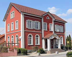
Français : La mairie et l'ancienne école de Dietwiller Deutsch: Rathaus und ehemalige Grundschule der Gemeinde Dietwiller |
| Date | |
| Source | Self-photographed |
| Author | Rauenstein |
| Permission (Reusing this file) |
This file is licensed under the Creative Commons Attribution-Share Alike 3.0 Unported license.
|
| Object location | | View this and other nearby images on: OpenStreetMap |
|---|
|
This building is indexed in the base Mérimée, a database of architectural heritage maintained by the French Ministry of Culture, under the reference IA00122510
|
File history
Click on a date/time to view the file as it appeared at that time.
| Date/Time | Thumbnail | Dimensions | User | Comment | |
|---|---|---|---|---|---|
| current | 05:31, 31 December 2023 | | 3,830 × 3,068 (2 MB) | Rauenstein (talk | contribs) | {{Information |Description={{fr|La mairie et l'ancienne école de Dietwiller}} {{de|Rathaus und ehemalige Grundschule der Gemeinde Dietwiller}} |Source={{self-photographed}} |Date=2010-04-10 |Author=Rauenstein |Permission={{cc-by-sa-3.0}} |other_versions= }} {{Object location|47|41|31.09|N|7|24|5.39|E}} {{Mérimée|IA00122510}} mairie Category:Monuments à l’inventaire in Arrondissement Mulhouse [[Category:Ma... |
| 11:47, 11 April 2010 |  | 3,057 × 2,266 (3.3 MB) | Rauenstein (talk | contribs) | {{Information |Description={{fr|La mairie de Dietwiller}} {{de|Gemeindeverwaltung in Dietwiller}} |Source=own photograph |Date=2010-04-10 |Author=Rauenstein |Permission={{cc-by-sa-3.0}} |other_vers |
You cannot overwrite this file.
File usage on Commons
The following 3 pages use this file:
File usage on other wikis
The following other wikis use this file:
- Usage on als.wikipedia.org
- Usage on br.wikipedia.org
- Usage on ca.wikipedia.org
- Usage on ceb.wikipedia.org
- Usage on ce.wikipedia.org
- Usage on de.wikipedia.org
- Usage on diq.wikipedia.org
- Usage on en.wikipedia.org
- Usage on es.wikipedia.org
- Usage on eu.wikipedia.org
- Usage on fr.wikipedia.org
- Usage on hu.wikipedia.org
- Usage on it.wikipedia.org
- Usage on lld.wikipedia.org
- Usage on ms.wikipedia.org
- Usage on nl.wikipedia.org
- Usage on oc.wikipedia.org
- Usage on pfl.wikipedia.org
- Usage on pl.wikipedia.org
- Usage on pt.wikipedia.org
- Usage on ro.wikipedia.org
- Usage on ru.wikipedia.org
- Usage on sh.wikipedia.org
- Usage on sk.wikipedia.org
- Usage on sl.wikipedia.org
- Usage on sr.wikipedia.org
- Usage on tt.wikipedia.org
- Usage on uk.wikipedia.org
- Usage on uz.wikipedia.org
- Usage on vec.wikipedia.org
- Usage on www.wikidata.org
- Usage on zh-min-nan.wikipedia.org
- Usage on zh.wikipedia.org