File:Dialects of the french language.png
Jump to navigation
Jump to search

Size of this preview: 800 × 364 pixels. Other resolutions: 320 × 146 pixels | 640 × 291 pixels | 1,024 × 466 pixels | 1,280 × 583 pixels | 2,688 × 1,224 pixels.
Original file (2,688 × 1,224 pixels, file size: 799 KB, MIME type: image/png)
Captions
Captions
Add a one-line explanation of what this file represents

|
This linguistic map image could be re-created using vector graphics as an SVG file. This has several advantages; see Commons:Media for cleanup for more information. If an SVG form of this image is available, please upload it and afterwards replace this template with
{{vector version available|new image name}}.
It is recommended to name the SVG file “Dialects of the french language.svg”—then the template Vector version available (or Vva) does not need the new image name parameter. |
Summary
[edit]| Description |
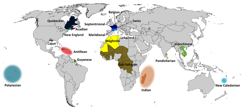
English: Dialects of the French language in the world |
| Date | |
| Source | Own work |
| Author | Jonatan argento |
| Other versions |
|


Licensing
[edit]
I, the copyright holder of this work, hereby publish it under the following license:
This file is licensed under the Creative Commons Attribution-Share Alike 3.0 Unported license.
- You are free:
- to share – to copy, distribute and transmit the work
- to remix – to adapt the work
- Under the following conditions:
- attribution – You must give appropriate credit, provide a link to the license, and indicate if changes were made. You may do so in any reasonable manner, but not in any way that suggests the licensor endorses you or your use.
- share alike – If you remix, transform, or build upon the material, you must distribute your contributions under the same or compatible license as the original.
File history
Click on a date/time to view the file as it appeared at that time.
| Date/Time | Thumbnail | Dimensions | User | Comment | |
|---|---|---|---|---|---|
| current | 04:45, 18 August 2020 | | 2,688 × 1,224 (799 KB) | Simtropolitan (talk | contribs) | +S Sudan border |
| 14:37, 9 May 2019 |  | 2,688 × 1,224 (793 KB) | Simtropolitan (talk | contribs) | Added New England French dialect, endangered; did not add Missourian French as that seems to be extinct (12 speakers estimate in 2015) | |
| 02:28, 1 March 2016 |  | 2,688 × 1,224 (683 KB) | Djr13 (talk | contribs) | Remove text title from map itself; Cropped 2 % horizontally and 20 % vertically using CropTool with precise mode. | |
| 17:17, 23 November 2014 |  | 2,753 × 1,538 (666 KB) | Abrahamic Faiths (talk | contribs) | Remove borders from Vojvadina (which has never been independent) and East Germany (which has been part of Germany since 1989). | |
| 08:30, 25 September 2011 |  | 2,753 × 1,538 (799 KB) | Jonatan argento (talk | contribs) | Fondo blanco. | |
| 07:44, 25 September 2011 |  | 2,753 × 1,538 (848 KB) | Jonatan argento (talk | contribs) |
You cannot overwrite this file.
File usage on Commons
The following 5 pages use this file:
File usage on other wikis
The following other wikis use this file:
- Usage on ba.wikipedia.org
- Usage on en.wikipedia.org
- Usage on en.wikiversity.org
- Usage on fa.wikipedia.org
- Usage on he.wikipedia.org
- Usage on kk.wikipedia.org
- Usage on pnb.wikipedia.org
- Usage on ru.wikipedia.org
- Usage on sr.wikipedia.org
- Usage on tr.wikipedia.org
- Usage on tyv.wikipedia.org
- Usage on ur.wikipedia.org