File:Diaľnice a rýchlostné cesty na Slovensku.png
Jump to navigation
Jump to search

Size of this preview: 800 × 415 pixels. Other resolutions: 320 × 166 pixels | 640 × 332 pixels | 1,039 × 539 pixels.
Original file (1,039 × 539 pixels, file size: 141 KB, MIME type: image/png)
Captions
Captions
Add a one-line explanation of what this file represents
Summary
[edit]| Description |
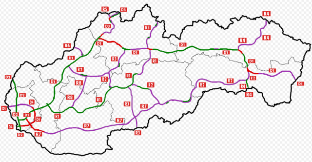
Slovenčina: Diaľnice a rýchlostné cesty na SK v roku 2016 |
|||
| Date | ||||
| Source | Own work | |||
| Author | TV Lopata | |||
| Other versions |
|


Licensing
[edit]
I, the copyright holder of this work, hereby publish it under the following license:
This file is licensed under the Creative Commons Attribution-Share Alike 4.0 International license.
- You are free:
- to share – to copy, distribute and transmit the work
- to remix – to adapt the work
- Under the following conditions:
- attribution – You must give appropriate credit, provide a link to the license, and indicate if changes were made. You may do so in any reasonable manner, but not in any way that suggests the licensor endorses you or your use.
- share alike – If you remix, transform, or build upon the material, you must distribute your contributions under the same or compatible license as the original.
File history
Click on a date/time to view the file as it appeared at that time.
| Date/Time | Thumbnail | Dimensions | User | Comment | |
|---|---|---|---|---|---|
| current | 19:04, 25 August 2017 | | 1,039 × 539 (141 KB) | TV Lopata (talk | contribs) | svrcinovec-skalite dokoncenie |
| 19:59, 24 May 2017 |  | 1,039 × 539 (141 KB) | TV Lopata (talk | contribs) | zvolen vychod-pstrusa, cadca bukov-svrcinovec | |
| 12:36, 6 April 2017 |  | 1,039 × 539 (141 KB) | TV Lopata (talk | contribs) | JZ OBCHVAT PRESOVA VO VYSTAVBE | |
| 19:30, 24 October 2016 |  | 1,039 × 539 (141 KB) | TV Lopata (talk | contribs) | doplnenie casti R7 (Prievoz-Ketelec) | |
| 15:32, 24 October 2016 |  | 1,039 × 539 (140 KB) | TV Lopata (talk | contribs) | aktualizacia-vystavba D4+R7, dokoncenie obchvatu Banoviec nad Bebravou | |
| 10:10, 24 September 2016 |  | 1,039 × 539 (140 KB) | TV Lopata (talk | contribs) | lepsie prehladnost obrazka | |
| 20:56, 23 September 2016 |  | 1,039 × 539 (130 KB) | TV Lopata (talk | contribs) | pridanie znacky dialnic a rychlostnych ciest | |
| 20:30, 23 September 2016 |  | 1,039 × 539 (132 KB) | TV Lopata (talk | contribs) | User created page with UploadWizard |
You cannot overwrite this file.
File usage on Commons
The following 9 pages use this file:
- User:Chumwa/OgreBot/Potential transport maps/2017 April 1-10
- User:Chumwa/OgreBot/Potential transport maps/2017 August 21-31
- User:Chumwa/OgreBot/Potential transport maps/2017 May 21-31
- User:Chumwa/OgreBot/Transport Maps/2017 April 1-10
- User:Chumwa/OgreBot/Transport Maps/2017 August 21-31
- User:Chumwa/OgreBot/Transport Maps/2017 May 21-31
- User:Chumwa/OgreBot/Travel and communication maps/2017 April 1-10
- User:Chumwa/OgreBot/Travel and communication maps/2017 August 21-31
- User:Chumwa/OgreBot/Travel and communication maps/2017 May 21-31