File:Devon oli 2020204 lrg.jpeg
From Wikimedia Commons, the free media repository
Jump to navigation
Jump to search

Size of this preview: 600 × 600 pixels. Other resolutions: 240 × 240 pixels | 480 × 480 pixels | 768 × 768 pixels | 1,024 × 1,024 pixels | 2,048 × 2,048 pixels | 9,204 × 9,204 pixels.
Original file (9,204 × 9,204 pixels, file size: 17.48 MB, MIME type: image/jpeg)
File information
Structured data
Captions
Captions
Add a one-line explanation of what this file represents
Summary
[edit]| Warning | The original file is very high-resolution. It might not load properly or could cause your browser to freeze when opened at full size. | Open in ZoomViewer |
|---|
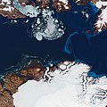
| DescriptionDevon oli 2020204 lrg.jpeg | The natural-color satellite image above shows the Truelove Lowlands—one of the areas on Devon Island that has conditions similar to those on Mars. It is also an especially lush part of the island and home to Poa arctica (arctic bluegrass) and Poa abbreviata (short bluegrass) . Unlike the Devon Ice Cap to the east, these lowlands are known for a having a milder and more hospitable microclimate than other parts of the island because nearby cliffs help regulate the temperature. In addition to the plants that carpet the surface in the summer, Truelove Lowlands attracts populations of muskoxen, foxes, and polar bears. The image was acquired by the Operational Land Imager (OLI) on Landsat 8 in July 2020. |
| Date | |
| Source | https://earthobservatory.nasa.gov/images/147053/cultivating-ideas-for-mars |
| Author | NASA Earth Observatory images by Joshua Stevens, using Landsat data from the U.S. Geological Survey. Story by Adam Voiland. |
Licensing
[edit]| Public domainPublic domainfalsefalse |
| This file is in the public domain in the United States because it was solely created by NASA. NASA copyright policy states that "NASA material is not protected by copyright unless noted". (See Template:PD-USGov, NASA copyright policy page or JPL Image Use Policy.) |  | |
 |
Warnings:
|
File history
Click on a date/time to view the file as it appeared at that time.
| Date/Time | Thumbnail | Dimensions | User | Comment | |
|---|---|---|---|---|---|
| current | 07:09, 25 May 2021 |  | 9,204 × 9,204 (17.48 MB) | StellarHalo (talk | contribs) | {{Information |Description=The natural-color satellite image above shows the Truelove Lowlands—one of the areas on Devon Island that has conditions similar to those on Mars. It is also an especially lush part of the island and home to Poa arctica (arctic bluegrass) and Poa abbreviata (short bluegrass) . Unlike the Devon Ice Cap to the east, these lowlands are known for a having a milder and more hospitable microclimate than other parts of the island because nearby cliffs help regulate the tem... |
You cannot overwrite this file.
File usage on Commons
There are no pages that use this file.
File usage on other wikis
The following other wikis use this file:
- Usage on lv.wikipedia.org
Metadata
This file contains additional information such as Exif metadata which may have been added by the digital camera, scanner, or software program used to create or digitize it. If the file has been modified from its original state, some details such as the timestamp may not fully reflect those of the original file. The timestamp is only as accurate as the clock in the camera, and it may be completely wrong.
| Orientation | Normal |
|---|---|
| Horizontal resolution | 72 dpi |
| Vertical resolution | 72 dpi |
| Software used | Adobe Photoshop 21.1 (Macintosh) |
| File change date and time | 16:14, 30 July 2020 |
| Color space | sRGB |
| Date and time of digitizing | 12:14, 30 July 2020 |
| Date metadata was last modified | 12:14, 30 July 2020 |
| Unique ID of original document | xmp.did:98ffb53c-7c4a-4c64-aea4-7f1350f81d5a |