File:Devecser és Kolontár térsége a vörösiszap katasztrófa után.jpg
Jump to navigation
Jump to search
No higher resolution available.
Devecser_és_Kolontár_térsége_a_vörösiszap_katasztrófa_után.jpg (720 × 360 pixels, file size: 194 KB, MIME type: image/jpeg)
Captions
Captions
Add a one-line explanation of what this file represents
Summary
[edit]
| Description |
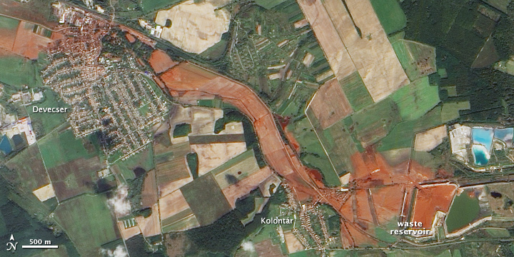
English: Natural-colour image of the area surrounding the toxic sludge spill in Hungary. The alumina plant appears along the right edge of the image and incorporates both bright blue and brick red reservoirs. The sludge forms a red-orange streak running west from the plant. This view shows the spill thinning but remaining discernible for several kilometres to the west.
Magyar: Az Ajkai vörösiszap-katasztrófa helyszíne, a NASA műhold képe |
| Date | |
| Source | NASA Earth Observatory |
| Author | Jesse Allen |
Image captured by the Advanced Land Imager (ALI) on NASA’s Earth Observing-1 (EO-1) satellite.
Licensing
[edit]
| This file is in the public domain in the United States because it was solely created by NASA. NASA copyright policy states that "NASA material is not protected by copyright unless noted". (See Template:PD-USGov, NASA copyright policy page or JPL Image Use Policy.) | ||
 |
Warnings:
|
File history
Click on a date/time to view the file as it appeared at that time.
| Date/Time | Thumbnail | Dimensions | User | Comment | |
|---|---|---|---|---|---|
| current | 11:04, 12 October 2010 | | 720 × 360 (194 KB) | Dencey~commonswiki (talk | contribs) | {{Information |Description={{en|1=Ajka}} |Source=http://earthobservatory.nasa.gov/IOTD/view.php?id=46360 |Author=Jesse Allen |Date=9 October 2010(2010-10-09) |Permission= |other_versions= }} Category:Ajka alumina plant accident |
You cannot overwrite this file.
File usage on Commons
There are no pages that use this file.
File usage on other wikis
The following other wikis use this file:
- Usage on el.wikipedia.org
- Usage on en.wikipedia.org
- Usage on fr.wikipedia.org
- Usage on hu.wikipedia.org
- Usage on it.wikipedia.org
- Usage on ja.wikipedia.org
- Usage on no.wikipedia.org
- Usage on pl.wikipedia.org
- Usage on vi.wikipedia.org