File:Deutschland Flussgebietseinheiten.png
Jump to navigation
Jump to search

Size of this preview: 446 × 599 pixels. Other resolutions: 178 × 240 pixels | 357 × 480 pixels | 571 × 768 pixels | 762 × 1,024 pixels | 1,718 × 2,309 pixels.
Original file (1,718 × 2,309 pixels, file size: 4.96 MB, MIME type: image/png)
Captions
Captions
Add a one-line explanation of what this file represents
Summary
[edit]| Description |
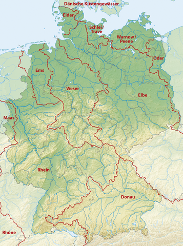
Deutsch: Karte der Flussgebietseinheiten in Deutschland (Richtlinie 2000/60/EG – Wasserrahmenrichtlinie) |
|
| Date | ||
| Source |
Own work using
|
|
| Author | NordNordWest | |
| Permission (Reusing this file) |
This file is licensed under the Creative Commons Attribution-Share Alike 3.0 Germany license.
 This file is licensed under the Creative Commons Attribution-Share Alike 3.0 Unported license.
|


|
This map has been made or improved in the German Kartenwerkstatt (Map Lab). You can propose maps to improve as well.
|
File history
Click on a date/time to view the file as it appeared at that time.
| Date/Time | Thumbnail | Dimensions | User | Comment | |
|---|---|---|---|---|---|
| current | 13:36, 17 July 2019 | | 1,718 × 2,309 (4.96 MB) | NordNordWest (talk | contribs) | corr |
| 18:39, 4 August 2011 |  | 1,718 × 2,309 (4.96 MB) | NordNordWest (talk | contribs) | == {{int:filedesc}} == {{Information |Description= {{de|Karte der Flussgebietseinheiten in Deutschland (Richtlinie 2000/60/EG – Wasserrahmenrichtlinie}} |Source= {{own}} using * Generic Mapping Tools, for re-creation, see |
You cannot overwrite this file.
File usage on Commons
The following 3 pages use this file:
File usage on other wikis
The following other wikis use this file:
- Usage on de.wikipedia.org
- Wasserscheiden in Deutschland
- Wikipedia:Kartenwerkstatt/Kartenwünsche
- Flussgebietseinheit
- Flussgebietseinheit Eider
- Flussgebietseinheit Schlei/Trave
- Flussgebietseinheit Warnow/Peene
- Flussgebietseinheit Elbe
- Dreiflussstein
- Wikipedia:Kartenwerkstatt/Archiv/2011-08
- Flussgebietseinheit Rhein
- Benutzer Diskussion:Brainswiffer/Archiv04
- Wikipedia:Auskunft/Archiv/2019/Woche 31
- Wikipedia Diskussion:WikiProjekt Geographie/Kategorien/Archiv 2017-1
- Usage on en.wikipedia.org
- Usage on es.wikipedia.org
- Usage on ja.wikipedia.org
- Usage on pl.wikipedia.org
- Usage on ru.wikipedia.org
- Usage on www.wikidata.org
- Usage on zh.wikipedia.org