File:Deutschen Kolonie Afrika - Togoland.png
Jump to navigation
Jump to search
No higher resolution available.
Deutschen_Kolonie_Afrika_-_Togoland.png (336 × 371 pixels, file size: 50 KB, MIME type: image/png)
Captions
Captions
Add a one-line explanation of what this file represents
Summary
[edit]
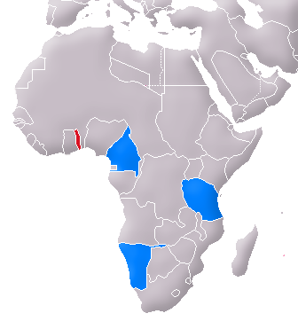
| Description | Location of Togoland (red) and the other German colonies in Africa (blue) |
| Date | 06.04.2007 |
| Source | Image:Map of the German Empire.PNG |
| Author | User:Flor!an |
| Other versions | de:Image:Karte Togo (1914).PNG |
.PNG)
Licensing
[edit]
| I, the copyright holder of this work, release this work into the public domain. This applies worldwide. In some countries this may not be legally possible; if so: I grant anyone the right to use this work for any purpose, without any conditions, unless such conditions are required by law. |
File history
Click on a date/time to view the file as it appeared at that time.
| Date/Time | Thumbnail | Dimensions | User | Comment | |
|---|---|---|---|---|---|
| current | 13:03, 6 May 2007 | | 336 × 371 (50 KB) | Flor!an (talk | contribs) | {{Information |Description= Location of Togoland (red) and the other German colonies in Africa (blue) |Source= Image:Map of the German Empire.PNG |Date= 06.04.2007 |Author= User:Flor!an |Permission= see below |other_versions= [[Image:Karte Togo ( |
You cannot overwrite this file.
File usage on Commons
There are no pages that use this file.
File usage on other wikis
The following other wikis use this file:
- Usage on ca.wikipedia.org
- Usage on cs.wikipedia.org
- Usage on da.wikipedia.org
- Usage on es.wikipedia.org
- Usage on fa.wikipedia.org
- Usage on hr.wikipedia.org
- Usage on pt.wikipedia.org
- Usage on sl.wikipedia.org
- Usage on sv.wikipedia.org