File:Deutsche Mundarten seit 1945.png
Jump to navigation
Jump to search

Size of this preview: 800 × 316 pixels. Other resolutions: 320 × 127 pixels | 640 × 253 pixels | 1,917 × 758 pixels.
Original file (1,917 × 758 pixels, file size: 72 KB, MIME type: image/png)
Captions
Captions
Add a one-line explanation of what this file represents

|
This linguistic map image could be re-created using vector graphics as an SVG file. This has several advantages; see Commons:Media for cleanup for more information. If an SVG form of this image is available, please upload it and afterwards replace this template with
{{vector version available|new image name}}.
It is recommended to name the SVG file “Deutsche Mundarten seit 1945.svg”—then the template Vector version available (or Vva) does not need the new image name parameter. |
Transferred from als.wikipedia to Commons by Maksim.
The original description page was here. All following user names refer to als.wikipedia.
Herkunft: Bild Deutsche Mundarten seit 1945.PNG aus der deutschen Wikipedia, von Benutzer Postmann Michael.
Folgende Angaben wurden von dort übernommen:
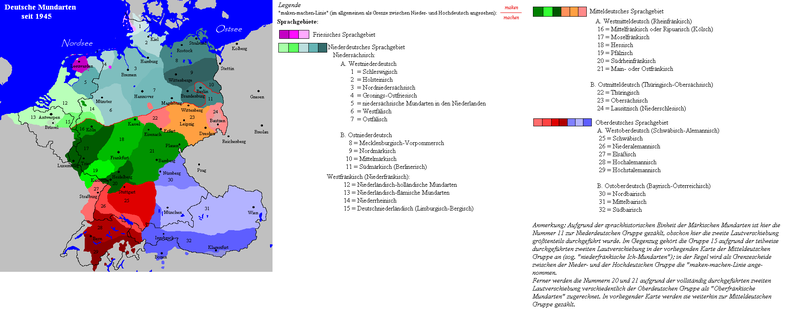
Gebiet der deutschen Mundarten seit Ende des 2. Weltkrieges.
- Beschreibung: Darstellungskarte zeigt die wichtigsten deutschen Mundarten der Gegenwart. Deutsche Außengrenze: 3. Oktober 1990.
- Zeichner: Postmann Michael
- erstellt am 14. Sept. 2004
- Quellen: Nach den Vorgaben des "Atlas" des Lingen-Verlages (1975) und dem "Großen Handlexikon in Farbe", Bertelsmann-Verlag (1979), sowie dem "dtv-Atlas zur deutschen Sprache", dtv-Verlag (9. Auflage;1992) wurde vorliegende Darstellungskarte angefertigt.
- Lizenzstatus: Public Domain
siehe auch/see also: Sprachenkarte aus dem aktuellen Meyers-Lexikon (übernommen vom Bertelsmann-Verlag) archive copy at the Wayback Machine----
| This work has been released into the public domain by its author, Postmann Michael at German Wikipedia. This applies worldwide. In some countries this may not be legally possible; if so: Postmann Michael grants anyone the right to use this work for any purpose, without any conditions, unless such conditions are required by law. |
Summary
[edit]
| Description |
English: Map of the German dialects after 1945. Note that it is incorrect, e.g.:
Deutsch: Karte der deutschen Mundarten nach 1945. Inhaltlich fehlerhaft. |
| Date | 14. Sept. 2004 |
| Source |
Angefertigt nach:
|
| Author | Postmann Michael |
File history
Click on a date/time to view the file as it appeared at that time.
| Date/Time | Thumbnail | Dimensions | User | Comment | |
|---|---|---|---|---|---|
| current | 18:39, 7 July 2009 | 1,917 × 758 (72 KB) | Badener (talk | contribs) | Lage von Karlsruhe korrigiert | |
| 16:42, 23 March 2007 | 1,917 × 758 (98 KB) | Gruna 1~commonswiki (talk | contribs) | correction around the Frisian-Groningan area - Bilts, Midlands, Gronings-Oostfries, enz. | ||
| 18:53, 24 January 2006 | 1,917 × 758 (100 KB) | Maksim (talk | contribs) | La bildo estas kopiita de wikipedia:als. La originala priskribo estas: '''Herkunft:''' Bild Deutsche Mundarten seit 1945.PNG aus der deutschen Wikipedia, von Benutzer Postmann Michael. Fol |
You cannot overwrite this file.
File usage on Commons
The following page uses this file:
File usage on other wikis
The following other wikis use this file:
- Usage on cy.wikipedia.org
- Usage on de.wikipedia.org
- Usage on hr.wikipedia.org
- Usage on nl.wikipedia.org
- Usage on ro.wikipedia.org
- Usage on ru.wikipedia.org